• About
    • At A Glance
    • Management Team
    • Board of Directors & Ownership
    • Our History
    • Corporate Social Responsibility
    • Quality Management
    • Health & Safety
    • Environmental Policy
    • Indigenous Relationships
    • Regions
      • Canada
      • Indonesia
      • Africa
  • Services
    • Water
      • Effects Monitoring & Ecotoxicology
      • Fish & Fish Habitat
      • Hydrogeology
      • Hydrology
      • Marine Ecology
      • Marine & Coastal Infrastructure
      • Regulatory Permitting
    • Land
      • Forest Management
      • Infrastructure Development
      • Regulatory Permitting
      • Terrestrial Ecology
    • People
      • Climate Change
      • Community Health & Wellbeing
      • Indigenous Relations
      • Socio-Economics
    • Technology
      • AI & Computer Vision
      • Data Analytics
      • GIS & Mapping
      • Remote Sensing
  • Sectors
    • Forestry
    • Infrastructure
    • International Development
    • Marine
    • Mining & Exploration
    • Oil & Gas
    • Pulp & Paper
    • Renewable Energy
  • Projects
  • News
  • Careers
    • Careers at Hatfield
    • Current Opportunities
    • Why Work at Hatfield?
  • Contact

AI & Computer Vision

Using advanced AI approaches to solve environmental
monitoring challenges

You are here: Home / Services / AI & Computer Vision

AI & Computer Vision

November 1, 2023 by

Hatfield is at the forefront of applying AI and computer vision techniques for environmental monitoring, including the development of novel AI and computer vision systems for our clients.

We apply our extensive knowledge of Earth observation sensors (including satellite, airborne, and terrestrial sensors), leading-edge computational methods, and partner with AI and computer vision experts to prototype, design, and deliver customized AI-driven solutions.

Our expertise includes:
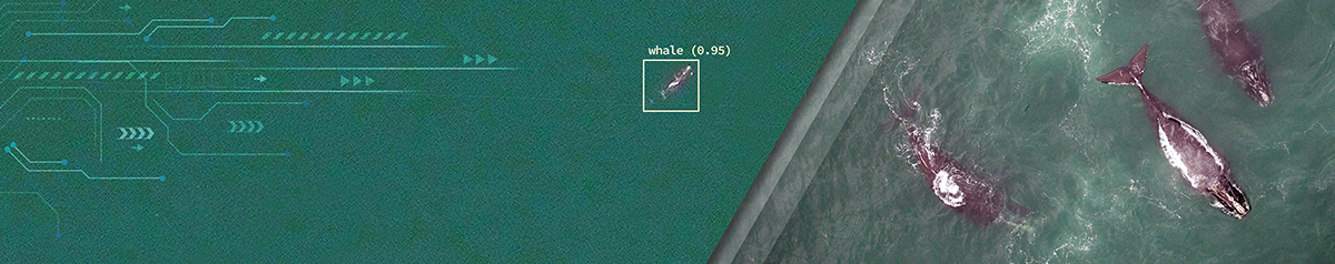
  • Object detection: identifying and locating objects of interest in satellite images using convolutional neural network (CNN) approaches, such as marine mammals, exemplified by our smartWhales space-based detection system.
  • Semantic Segmentation: using deep learning to categorize satellite images into different classes based on feature characteristics, such as texture, color, and shape. We apply these methods to identify linear disturbance in forest landscapes in research to support Woodland Caribou habitat management.
  • Cloud-based solutions: Hatfield develops cost-effective scalable cloud-based solutions that integrate model operation, sensor management, data visualization, and management tools. Hatfield’s GEOAnalytics Canada platform

Why Hatfield?

Hatfield is a trusted advisor to government, private sector, and non-government clients on the use of remote sensing technology for environmental monitoring and management around the world. If you are keen to explore AI and deep learning, we can help you navigate the options and bring together a project design and required partnerships for success.


Banner Photo Credit: WorldView-3 Image © 2023 Maxar Technologies

Water Services

  • WATER
  • Effects Monitoring & Ecotoxicology
  • Fish & Fish Habitat
  • Hydrogeology
  • Hydrology
  • Marine Ecology
  • Marine & Coastal Infrastructure
  • Regulatory Permitting

Land Services

  • LAND
  • Forest Management
  • Infrastructure Development
  • Regulatory Permitting
  • Terrestrial Ecology

People Services

  • PEOPLE
  • Climate Change
  • Community Health & Wellbeing
  • Indigenous Relations
  • Socio-Economics
  • TECHNOLOGY
  • AI and Computer Vision
  • Data Analytics
  • GIS & Mapping
  • Remote Sensing

Find out more about our services from our team of technical experts

Connect With Us

AI & Computer Vision Projects

SmartWhales – Development of Space-Based Solutions for the Monitoring and Protection of the North Atlantic Right Whale (NARW)
2021 - 2024
Madagascar National Mangrove Mapping from 2019 to 2023 for Pêche Côtière Durable Phase II
2020 - 2024
Landscape Linear Disturbance Mapping using Deep Learning Methods
2020 - 2022
All Projects

AI & Computer Vision Newsfeed

Hatfield to support environmental monitoring of Port of Montreal’s expansion project at Contrecœur with innovative satellite remote sensing applications
July 18th, 2023
Hatfield to support environmental monitoring of Port of Montreal’s expansion project at Contrecœur with innovative satellite remote sensing applications
Hatfield is excited to announce its collaboration with Public Services and Procurement Canada...
Hatfield leading new ESA ecosystem restoration initiative to develop open Earth observation tools for assessment and monitoring
March 30th, 2023
Hatfield leading new ESA ecosystem restoration initiative to develop open Earth observation tools for assessment and monitoring
Ecosystem Restoration is critical to reverse biodiversity loss and is an essential element...
Hatfield and AltaML announce progress on detection of endangered North Atlantic right whales using satellite Earth observation data
March 15th, 2022
Hatfield and AltaML announce progress on detection of endangered North Atlantic right whales using satellite Earth observation data
Vancouver, BC and Edmonton, AB – Hatfield Consultants, a leading environmental consultancy, and...
All News

Interested in joining our talented team?

Current Opportunities
  • Home
  • About
  • Projects
  • News
  • Careers
  • Contact
  • Agent Orange

Sectors

  • Forestry
  • Infrastructure
  • International Development
  • Marine
  • Mining & Exploration
  • Oil & Gas
  • Pulp & Paper
  • Renewable Energy

Services

  • WATER
  • Effects Monitoring & Ecotoxicology
  • Fish & Fish Habitat
  • Hydrogeology
  • Hydrology
  • Marine Ecology
  • Marine & Coastal Infrastructure
  • Regulatory Permitting
  • LAND
  • Forest Management
  • Infrastructure Development
  • Regulatory Permitting
  • Terrestrial Ecology
  • PEOPLE
  • Climate Change
  • Community Health & Wellbeing
  • Indigenous Relations
  • Socio-Economics
  • TECHNOLOGY
  • AI and Computer Vision
  • Data Analytics
  • GIS & Mapping
  • Remote Sensing
Copyright © Hatfield Consultants
  • Terms & Conditions
  • Privacy Policy
  • About
    ▼
    • At A Glance
    • Management Team
    • Board of Directors & Ownership
    • Our History
    • Corporate Social Responsibility
    • Quality Management
    • Health & Safety
    • Environmental Policy
    • Indigenous Relationships
    • Regions
      ▼
      • Canada
      • Indonesia
      • Africa
  • Services
    ▼
    • Water
      ▼
      • Effects Monitoring & Ecotoxicology
      • Fish & Fish Habitat
      • Hydrogeology
      • Hydrology
      • Marine Ecology
      • Marine & Coastal Infrastructure
      • Regulatory Permitting
    • Land
      ▼
      • Forest Management
      • Infrastructure Development
      • Regulatory Permitting
      • Terrestrial Ecology
    • People
      ▼
      • Climate Change
      • Community Health & Wellbeing
      • Indigenous Relations
      • Socio-Economics
    • Technology
      ▼
      • AI & Computer Vision
      • Data Analytics
      • GIS & Mapping
      • Remote Sensing
  • Sectors
    ▼
    • Forestry
    • Infrastructure
    • International Development
    • Marine
    • Mining & Exploration
    • Oil & Gas
    • Pulp & Paper
    • Renewable Energy
  • Projects
  • News
  • Careers
    ▼
    • Careers at Hatfield
    • Current Opportunities
    • Why Work at Hatfield?
  • Contact