Wetland Assessment and Monitoring using Multi EO Data and Advanced Analytics
Client
Canadian Space Agency (CSA)
Location
Alberta, Canada
Project Duration
October 2019 – 2021
Background
Wetlands are a critical part of our natural environment, improve water quality, support biodiversity, provide flood protection by increasing detention times of floodwaters, protect from storm and wave damage, recharge aquifers, and sequester carbon. Wetlands are however complex, dynamic natural habitats, that are difficult to characterize and monitor at a landscape scale due to the high variability in wetland morphology, including size, shape, and composition.
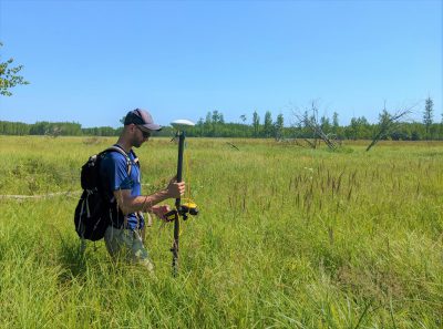
The Wetland Assessment and Monitoring using Multi Earth Observation Data and Advanced Analytics project (WAM-EO) advances wetland classification and monitoring methods using multi-sourced data for broad application across boreal and prairie-grassland wetland ecosystems. The project uses radar data (e.g., Sentinel-1 and RADARSAT missions), multi-spectral data (e.g., Sentinel-2), and airborne LiDAR point cloud and elevation surface models, and other supporting EO data. A main objective is to stimulate collaboration among federal and provincial government, academia, and the private sector to develop innovative solutions to support climate change policy and action
Services Provided
Hatfield developed advanced techniques to accurately characterize and monitor wetland size, shape, and composition using multi-source EO data. The innovative approach utilized the strengths of Object-Oriented Image Analysis and the power of machine learning methods (e.g., Random Forest) for wetland class and form assignment.
The wetland classification approach, developed in collaboration with University of Lethbridge, followed the Alberta Wetland Classification System to be compatible with the Canadian Wetland Classification System. The results were shared with Alberta Environment and Parks, Environment Canada, Parks Canada, and Natural Resources Canada, the project outcomes support government and development proponents in selecting the most suitable wetland mapping approach to meet wetland protection goals and regulatory requirements.