River and Lake Bathymetry Services
Client(s):
Various
Location:
Various locations in Alberta, Canada.
Dates:
June 2022 – December 2023
Background:
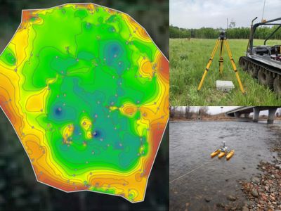
Hatfield is capable of providing bathymetric surveying and assessment services to support a diverse range of projects. Field staff have experience using various bathymetric instrumentation from acoustic doppler current profilers (ADCPs) paired with real-time kinematic (RTK) global position systems to sonar scanner systems. Hatfield’s in-house Geomatics experts support in post-data processing to produce bathymetry maps for our clients. Each project is tailored to the specific needs and objectives of the clients.
Services Provided:
Ivor Strong Bridge Bow River Bathymetry: Hatfield was retained by the City of Calgary to support construction of the Ivor Strong Bridge expansion by collecting bathymetry data. In conjunction with the bathymetry, Hatfield also completed an aquatics survey by a Qualified Aquatic Environmental Specialist (QAES) in the hydraulic zone of influence to identify potential brown trout redds spawning activity, sensitive habitat features and potential offsetting opportunities. Bathymetry data were collected using an acoustic Doppler current profiler (ADCP) paired with a real-time kinematic (RTK) global positioning system (GPS). The ADCP was mounted on a small plastic boat (SonTek Hydroboard), tethered 5 meters (m) behind a Zebec inflatable boat. A total track length of 1,668 m with a total coverage of 449 m2 being mapped upstream and downstream of the Ivor Strong Bridge.
Fox Lake Barge Crossing Bathymetry: Hatfield was retained by Little Red Cree Nation (LRRCN) to complete a bathymetric survey on the Peace River to support the community of Fox Lake in rebuilding the community after a wildfire. The bathymetry was collected using a Garmin Echomap UHD 75cv from 20 m upstream and downstream of each existing ferry launch. A total track length of 26 km with a total coverage of 0.97 km2 was mapped.
Sinkhole Lake Bathymetry: Hatfield was retained to complete bathymetric surveys and water chemistry profiling sampling to support the geohazards assessment of the Fort Hills North Pit area. A total of fourteen (14) sinkhole lakes were included as part of the scope with variable access from the use of ARGO and helicopter; four (4) were not sampled due to insufficient water depths. While on the ponds, a zodiac with an electric trolling motor or similar was used with a Garmin depth sounder to collect bathymetry measurements. The water column profile profiling was conducted at the deepest part of each lake with intervals ranging from 0.5 to 1.0.