• About
    • At A Glance
    • Management Team
    • Board of Directors & Ownership
    • Our History
    • Corporate Social Responsibility
    • Quality Management
    • Health & Safety
    • Environmental Policy
    • Indigenous Relationships
    • Regions
      • Canada
      • Indonesia
      • Africa
  • Services
    • Water
      • Effects Monitoring & Ecotoxicology
      • Fish & Fish Habitat
      • Hydrogeology
      • Hydrology
      • Marine Ecology
      • Marine & Coastal Infrastructure
      • Regulatory Permitting
    • Land
      • Forest Management
      • Infrastructure Development
      • Regulatory Permitting
      • Terrestrial Ecology
    • People
      • Climate Change
      • Community Health & Wellbeing
      • Indigenous Relations
      • Socio-Economics
    • Technology
      • AI & Computer Vision
      • Data Analytics
      • GIS & Mapping
      • Remote Sensing
  • Sectors
    • Forestry
    • Infrastructure
    • International Development
    • Marine
    • Mining & Exploration
    • Oil & Gas
    • Pulp & Paper
    • Renewable Energy
  • Projects
  • News
  • Careers
    • Careers at Hatfield
    • Current Opportunities
    • Why Work at Hatfield?
  • Contact

Mapping Forest Parameters for Sustainable Wood Product Supply Management

You are here: Home / Projects / Mapping Forest Parameters for Sustainable Wood Product Supply Management

Mapping Forest Parameters for Sustainable Wood Product Supply Management

Client

Not disclosed

Location

Southern USA

Project Duration

March 2019 – March 2020
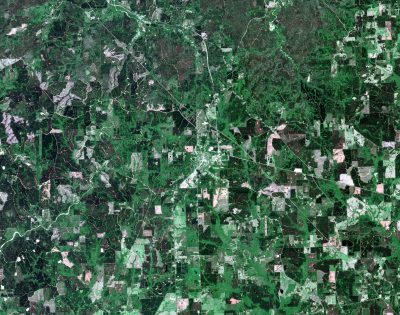
Background

A company that sources wood products in the southern United States of America (USA) wanted to establish a monitoring framework to enable reliable tracking and reporting of the key dimensions of forest landscape health.

Services Provided

Hatfield implemented a service to monitor forest attributes annually from 2010-2020 in supply catchments in the Southern USA. The attributes addressed were:

  • Forest cover – deforestation/afforestation, including changes such deciduous/coniferous composition and fragmentation/consolidation of forest in the landscape.
  • Forest carbon – change above ground carbon stock using the forest cover maps and US Forest Inventory and Analysis (FIA) plot data.
  • Biodiversity values – identifying areas with statutory protection and High Conservation Value (HCV).

Data integrated to deliver the service included airborne Lidar, Landsat-5/7/8, Sentinel-2, FIA plot data, and other state and federal geospatial data. The service integrated satellite Earth observation data time series trend analysis, machine learning classification, and other geospatial analytics.

Mapping Forest Parameters for Sustainable Wood Product Supply Management

June 15, 2020 by

Find out more about our services from our team of technical experts

Connect With Us
  • Home
  • About
  • Projects
  • News
  • Careers
  • Contact
  • Agent Orange

Sectors

  • Forestry
  • Infrastructure
  • International Development
  • Marine
  • Mining & Exploration
  • Oil & Gas
  • Pulp & Paper
  • Renewable Energy

Services

  • WATER
  • Effects Monitoring & Ecotoxicology
  • Fish & Fish Habitat
  • Hydrogeology
  • Hydrology
  • Marine Ecology
  • Marine & Coastal Infrastructure
  • Regulatory Permitting
  • LAND
  • Forest Management
  • Infrastructure Development
  • Regulatory Permitting
  • Terrestrial Ecology
  • PEOPLE
  • Climate Change
  • Community Health & Wellbeing
  • Indigenous Relations
  • Socio-Economics
  • TECHNOLOGY
  • AI and Computer Vision
  • Data Analytics
  • GIS & Mapping
  • Remote Sensing
Copyright © Hatfield Consultants
  • Terms & Conditions
  • Privacy Policy
  • About
    ▼
    • At A Glance
    • Management Team
    • Board of Directors & Ownership
    • Our History
    • Corporate Social Responsibility
    • Quality Management
    • Health & Safety
    • Environmental Policy
    • Indigenous Relationships
    • Regions
      ▼
      • Canada
      • Indonesia
      • Africa
  • Services
    ▼
    • Water
      ▼
      • Effects Monitoring & Ecotoxicology
      • Fish & Fish Habitat
      • Hydrogeology
      • Hydrology
      • Marine Ecology
      • Marine & Coastal Infrastructure
      • Regulatory Permitting
    • Land
      ▼
      • Forest Management
      • Infrastructure Development
      • Regulatory Permitting
      • Terrestrial Ecology
    • People
      ▼
      • Climate Change
      • Community Health & Wellbeing
      • Indigenous Relations
      • Socio-Economics
    • Technology
      ▼
      • AI & Computer Vision
      • Data Analytics
      • GIS & Mapping
      • Remote Sensing
  • Sectors
    ▼
    • Forestry
    • Infrastructure
    • International Development
    • Marine
    • Mining & Exploration
    • Oil & Gas
    • Pulp & Paper
    • Renewable Energy
  • Projects
  • News
  • Careers
    ▼
    • Careers at Hatfield
    • Current Opportunities
    • Why Work at Hatfield?
  • Contact