SmartWhales – Development of Space-Based Solutions for the Monitoring and Protection of the North Atlantic Right Whale (NARW)
Client
Canadian Space Agency
Location
Gulf of St. Lawrence, Canada
Project Duration
January 2021 – June 2024
Background
The Canadian Space Agency (CSA) smartWhales initiative aims to develop solutions to support the protection of the North Atlantic right whales (NARW). With overall funding of $5.3-million from the federal government, and in collaboration with Fisheries and Oceans Canada (DFO) and Transport Canada (TC), smartWhales utilizes satellite Earth observation data to help detect and monitor the presence of the NARWs in Canadian waters in near-real time, while predicting their movements and monitoring their safety.
Following the devastating increase in NARW mortalities over recent years, from collisions with vessels and entanglement in fishing gear, innovative solutions to better protect and track the whales are needed. The CSA enlisted five consortia to develop smartWhales solutions using space-based technologies.
Services Provided
Hatfield leads a multi-disciplinary consortium of industry scientists, academia, and non-government organizations to develop a platform to detect and monitor NARWs using deep learning models, high-resolution space-based satellite imagery, automation, and geoscience computing.
The smartWhales space-based detection system (SBDS) leverages the latest developments in very high-resolution (VHR) space-based Earth observation satellites, deep learning models, and big geoscience data cloud computing. The SBDS objective is to detect NARW and report observations in near-real time, cost-effectively covering large areas of Canada’s east coast as a complement to existing monitoring technologies. Hosted in a scalable cloud computing platform, the smartWhales SBDS uses VHR space-based Earth observation data and applies computer vision to detect NARW.
The technical objectives are to:
- Train and validate a range of deep learning and AI algorithms to detect NARW in VHR satellite images.
- Utilize a big data geoscience platform to enable scalable, near-real-time data access, processing, and distribution.
- Demonstrate how the smartWhales SBDS can be complementary and be integrated with other NARW monitoring technologies (e.g., passive acoustic sensors (gliders).
To date, Hatfield has:
- Completed a comprehensive state-of-the-art review on the use of satellite data and machine learning for marine megafauna detection and monitoring.
- Developed a two-stage satellite image-based AI detection model to identify large marine megafauna.
- Developed a fully automated processing pipeline, validation and labelling tool, and map-based visualization interface.
- Conducted and completed two real-world demonstrations of the smartWhales SBDS.
- Completed research into potential approaches to use aerial-based images (drone or fixed-wing) as additional training data in a satellite-based AI detection model.
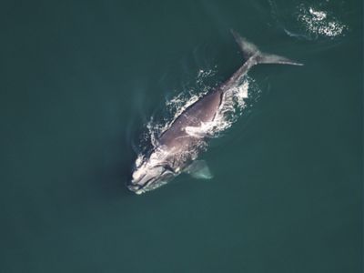
Photo credit: Aerial photo of North Atlantic Right Whale, Catalog #4714, NARWC, 2019.