Ice Monitoring
Client
Canadian Space Agency, European Space Agency, Government of Northwest Territories
Location
Northwest Territories, Quebec, and Alberta, Canada
Project Duration
March 2008 – March 2021 (multiple projects)
Background
Freshwater ecosystems are of fundamental importance to northern communities in Canada, and the region’s lakes, rivers, and wetlands are a defining feature of the landscape. For example, the Northwest Territories contains hundreds of thousands of lakes that extend across the vast territory.
Changes in climate, warming temperatures, and increased precipitation are impacting surface water resources, however monitoring is challenging due to the territories’ size and difficulty accessing remote areas. This results in information gaps related to the state and health of aquatic ecosystems for effective water resources stewardship.
Services Provided
Satellite remote sensing is a valuable tool to monitor variability in water resources. Hatfield developed remote sensing analytics related to long-term monitoring of water resources, including ice formation, growth, and breakup on rivers and lakes, which provide insights into how ice cover plays a role in water resources and how it responds to climate variability.
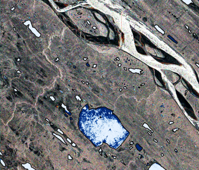
Grounded Ice Detection (GUIDE) algorithm – Hatfield developed an algorithm that is applied to multi-temporal synthetic aperture radar (SAR) data to map the extent of grounded or bottomfast ice. This information provides valuable information on relative depth of shallow lakes, sensitivity to fish over-wintering habitat, and potential for water withdrawal and use by transportation and resource industries. Using SAR images and a function called dynamic time warping (DTW), which provides a shape-based similarity metric for time series data, backscatter profiles from surveyed lakes with known grounded ice are used to generate DTW values on a pixel-by-pixel basis to detect and map grounded ice. The approach that Hatfield developed has proven to be an effective technique to map grounded ice and has potential to address limitations of other approaches where certain ice structures over deep lakes can produce backscatter responses similar to grounded ice. Our research was published in the Canadian Journal of Remote Sensing in 2019.
River ice classification – Ice formation on rivers is a highly complex and dynamic process that eventually leads to complete and continuous ice cover. The significance of river ice is multi-faceted given it controls the winter flow regimes of most rivers; provides seasonal transportation corridors for remote communities; can be hazardous to shipping; may influence weather patterns; and might be an indicator to climate change. The formation of consolidated ice is of particular importance since it could potentially cause ice damming and flooding over large areas. Hatfield’s ice monitoring service provides important information on the location and extent of ice cover. It helps delineate and identify river ice types, ice breakup, and ice conditions to support ice travel safety, flood risk management, and strategic planning for downstream infrastructures.
Coastal sea ice classification – Coastal sea ice, specifically shore ice, plays an important role in protecting Canada’s coastline, most notably in polar and subpolar areas where the observed acceleration of coastal change is largely associated with a decreasing sea ice extent that increases shoreline exposure to storm‐surge floods and erosion. As part of the Canadian Space Agency’s Climate Change Impact and Ecosystem Resilience (CCIER) initiative, Hatfield applied a depth of experience in the use of SAR to detect and map shore ice over time to better understand the dynamics of shore ice as it plays a key role in protecting coastal zones. We worked jointly with project partners to study sites along the estuary and Gulf of St. Lawrence (EGSL) to develop and test innovative EO-based tools to monitor the impact of climate change.