• About
    • At A Glance
    • Management Team
    • Board of Directors & Ownership
    • Our History
    • Corporate Social Responsibility
    • Quality Management
    • Health & Safety
    • Environmental Policy
    • Indigenous Relationships
    • Regions
      • Canada
      • Indonesia
      • Africa
  • Services
    • Water
      • Effects Monitoring & Ecotoxicology
      • Fish & Fish Habitat
      • Hydrogeology
      • Hydrology
      • Marine Ecology
      • Marine & Coastal Infrastructure
      • Regulatory Permitting
    • Land
      • Forest Management
      • Infrastructure Development
      • Regulatory Permitting
      • Terrestrial Ecology
    • People
      • Climate Change
      • Community Health & Wellbeing
      • Indigenous Relations
      • Socio-Economics
    • Technology
      • AI & Computer Vision
      • Data Analytics
      • GIS & Mapping
      • Remote Sensing
  • Sectors
    • Forestry
    • Infrastructure
    • International Development
    • Marine
    • Mining & Exploration
    • Oil & Gas
    • Pulp & Paper
    • Renewable Energy
  • Projects
  • News
  • Careers
    • Careers at Hatfield
    • Current Opportunities
    • Why Work at Hatfield?
  • Contact

Groundwater Level Forecasting using Machine Learning

You are here: Home / Projects / Groundwater Level Forecasting using Machine Learning

Groundwater Level Forecasting using Machine Learning

Client:

Ministry of Water, Land and Resource Stewardship

Location:

British Columbia

Dates:

2024 – 2025

Background:

The River Forecast Centre (RFC) of the Ministry of Water, Land and Resource Stewardship (WLRS) has been using real-time daily groundwater level data from select Provincial Groundwater Observation Wells Network (PGOWN) wells across British Columbia and comparing these data to historical groundwater level percentile ranges to assess aquifer conditions during the spring-summer core drought season. These comparisons aid in shaping drought response strategies and are posted on the BC Drought Portal. WLRS wanted to explore whether the introduction of early season (e.g., April-June) indicators for potential groundwater drought conditions to occur in summer could offer an additional early warning system, as used elsewhere in North America.  The province’s diverse hydro climatology, small and responsive aquifers, and the intricate interactions between groundwater and surface water result in complex groundwater level responses that show distinct variations between and within hydroclimatic and aquifer settings. These complexities present challenges when trying to understand and predict the potential for groundwater drought conditions to occur that needed to be incorporated in the project.

Services Provided:

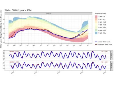
Hatfield developed and tested several different statistical and machine learning modelling approaches to forecast groundwater levels up to 90 days in advance of current conditions using hydroclimatic predictor variables. Models considered included Generalized Additive Models (GAM), Generalized Linear Models (GLM), Artificial Neural Network (ANN) and Random Forest (RF). In snowmelt aquifer recharge settings, key hydroclimatic forecast variables included historic groundwater levels, temperature, precipitation, snow water equivalent (SWE) and snowmelt rate (the change in SWE over a defined period). In rainfall recharge dominated systems the key climate variables used were precipitation and temperature.  It was found that both data on antecedent conditions (i.e. conditions at time groundwater level forecast is made) and seasonal predictor variables (i.e., future climate conditions) needed to be included in the forecasts. The use of prior hydroclimatic data on antecedent conditions accounted for aquifer recharge lag time (i.e. the time between a precipitation or snowmelt event and corresponding groundwater level response).

The operational forecast tools developed allow for the determination of the percent likelihood of predicted groundwater levels to be above normal, normal or below-normal using results from Monte Carlo simulations. Short-term (up to 16-da y) precipitation and temperature forecast data from RFC were integrated to reduce uncertainty in groundwater level forecasts, while using historical climate variability beyond 16 days. ANN model forecasts were found to have the highest number of PGOWN wells with good model validation performance considering 2004-2024 historical data. It was therefore recommended by Hatfield that RFC operational forecasting solely be done with the ANN model, with 152 PGOWN wells considered suitable for groundwater level forecasting in different parts of British Columbia.

Groundwater Level Forecasting using Machine Learning

Groundwater Level Forecasting using Machine Learning

August 11, 2025 by

Find out more about our services from our team of technical experts

Connect With Us
  • Home
  • About
  • Projects
  • News
  • Careers
  • Contact
  • Agent Orange

Sectors

  • Forestry
  • Infrastructure
  • International Development
  • Marine
  • Mining & Exploration
  • Oil & Gas
  • Pulp & Paper
  • Renewable Energy

Services

  • WATER
  • Effects Monitoring & Ecotoxicology
  • Fish & Fish Habitat
  • Hydrogeology
  • Hydrology
  • Marine Ecology
  • Marine & Coastal Infrastructure
  • Regulatory Permitting
  • LAND
  • Forest Management
  • Infrastructure Development
  • Regulatory Permitting
  • Terrestrial Ecology
  • PEOPLE
  • Climate Change
  • Community Health & Wellbeing
  • Indigenous Relations
  • Socio-Economics
  • TECHNOLOGY
  • AI and Computer Vision
  • Data Analytics
  • GIS & Mapping
  • Remote Sensing
Copyright © Hatfield Consultants
  • Terms & Conditions
  • Privacy Policy
  • About
    ▼
    • At A Glance
    • Management Team
    • Board of Directors & Ownership
    • Our History
    • Corporate Social Responsibility
    • Quality Management
    • Health & Safety
    • Environmental Policy
    • Indigenous Relationships
    • Regions
      ▼
      • Canada
      • Indonesia
      • Africa
  • Services
    ▼
    • Water
      ▼
      • Effects Monitoring & Ecotoxicology
      • Fish & Fish Habitat
      • Hydrogeology
      • Hydrology
      • Marine Ecology
      • Marine & Coastal Infrastructure
      • Regulatory Permitting
    • Land
      ▼
      • Forest Management
      • Infrastructure Development
      • Regulatory Permitting
      • Terrestrial Ecology
    • People
      ▼
      • Climate Change
      • Community Health & Wellbeing
      • Indigenous Relations
      • Socio-Economics
    • Technology
      ▼
      • AI & Computer Vision
      • Data Analytics
      • GIS & Mapping
      • Remote Sensing
  • Sectors
    ▼
    • Forestry
    • Infrastructure
    • International Development
    • Marine
    • Mining & Exploration
    • Oil & Gas
    • Pulp & Paper
    • Renewable Energy
  • Projects
  • News
  • Careers
    ▼
    • Careers at Hatfield
    • Current Opportunities
    • Why Work at Hatfield?
  • Contact