arboSense fuels – Prototype Gridded Forest Fuel Metrics for Wildfire Risk Management
Client:
Natural Resources Canada (NRCan)
Location:
Alberta, Canada
Dates:
April 2023 to August 2023
Background:
NRCan sought the development of a software solution for the creation of high-resolution forest fuel attribute data (up to 1m resolution) in wildland urban interface areas and wildland areas near communities. The purpose was to support detailed fire behavior prediction, fire hazard assessment, and fire hazard mitigation activity planning. The requirement was validated analytical models and a prototype software solution to use available and/or newly collected point cloud data to generate fuels attribute information as input to the Canadian Fire Behaviour Prediction (FBP) System, and for wider wildfire planning and response applications.
Services Provided:
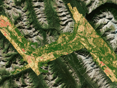
Hatfield led the modeling and development of the solution in collaboration with the University of Lethbridge. We developed a prototype of arboSense fuels – a software solution to produce gridded forest metrics that provide inputs to the FBP System of the Canadian Forest Fire Danger Rating System (CFFDRS). At present, 16 fuel types are mapped across Canada (Beaudoin et al 2014), but the level of spatial details and precision of this dataset is relatively limited. To address these challenges, our arboSense fuels solution targets a new set of FBP system attributes that are more intrinsically linked to forest fuel characteristics – overstory fuels (canopy fuels) and under canopy fuels (ladder fuels) attribute types, with improved spatial resolution.
Our solution is a software tool for processing airborne laser scanning (ALS) derived point clouds to generate fuel attribute maps, addressing the two following mapping scenarios:
- Planning – Able to guide FireSmart treatment design and aid in prescribed burn operations by attaining map products at multiple resolutions down to 1 m.
- Response – Requires little supplemental data and able to be completed on a standalone computer allowing for computation and production in the field.
Using ground-based fuels plot data collected in Jasper, Banff, and Waterton National Park, Alberta, we developed a suite of models to generate fuel attributes, including canopy height, canopy cover, canopy base height, canopy fuel load, canopy bulk density, and basal area. The models are validated, and the performance of the system is also benchmarked for processing speed on powerful standalone computers.
To learn more view our arboSense fuels Story Map.