Climate Change Assessment – Infrastructure and Cultural Sites
Client
BC Parks
Location
British Columbia
Project Duration
November 2021 – April 2022
Background
Several of Canada’s worst and most expensive natural disasters have occurred very recently, such as the record heatwave and flooding events across south-western BC in 2021, the Fort McMurray wildfire in 2016, and southern Albertan floods in 2013. Future natural disasters are inevitable; the International Panel on Climate Change (IPCC) Sixth Assessment Report recently concluded with ‘high confidence’ that under all future climate scenarios and global warming levels, temperatures including extremely high temperatures and the frequency and intensity of both heavy precipitation events and droughts will increase for northern regions such as Canada.
Hatfield is now regularly meeting its client’s needs to integrate climate change projections into their environmental impact assessments, vulnerability assessments and/or climate adaptation studies. Most recently, Hatfield’s Human Environment, Water Resources, and Geomatics Business groups, along with colleagues from the Climate Risk Institute and Smart Shores, teamed up to complete a large Climate Change Vulnerability Assessment project for BC Parks. The purpose of the project was to better prepare the agency to respond to anticipated increases in climate-related hazard risks and infrastructure costs. Severe weather events inhibit the ability of BC Parks to deliver on its Vision and Mission, and in 2021 alone, BC Parks saw an estimated $8.4 million in damages across the system due to severe weather events.
Services Provided
A survey and series of interviews with BC Parks managers and operations staff in each of 12 regional administrative sections across BC helped to identify key climate hazards of most concern to staff, and the types of infrastructure that have been most impacted. A Climate and Environmental Change factsheet was produced for each region, illustrating the changes in frequency of identified extreme climate events (e.g., heatwaves, storm events) and associated hazards (e.g., wildfire, flooding, sea-level rise) predicted to occur in future decades based on latest global climate model projections and other data. This information was then integrated within a version of the PIEVC Engineering Protocol to build a customized vulnerability assessment tool for BC Parks’ infrastructure and cultural sites.
Project deliverables included a final report with recommendations and a list of key action items to increase adaptive capacity and build resilience over time. The accompanying vulnerability assessment tool and regional climate hazard fact sheets will help raise awareness across the agency and provide a practical starting point for long-term climate change adaptation planning to help BC Parks prepare for a future under a changing climate.
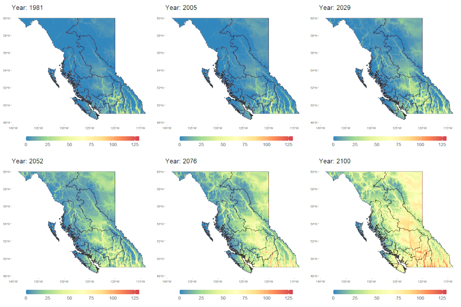
The image on the right side is an example of projected changes in extreme heat, 1981-2100. Annual frequency (days/year) reaching 30°C across BC and BC Parks Sections (in black), under a very conservative scenario (RCP8.5 High Carbon Scenario; 90th percentile outcome from a large ensemble of Global Climate Models).
