• About
    • At A Glance
    • Management Team
    • Board of Directors & Ownership
    • Our History
    • Corporate Social Responsibility
    • Quality Management
    • Health & Safety
    • Environmental Policy
    • Indigenous Relationships
    • Regions
      • Canada
      • Indonesia
      • Africa
  • Services
    • Water
      • Effects Monitoring & Ecotoxicology
      • Fish & Fish Habitat
      • Hydrogeology
      • Hydrology
      • Marine Ecology
      • Marine & Coastal Infrastructure
      • Regulatory Permitting
    • Land
      • Forest Management
      • Infrastructure Development
      • Regulatory Permitting
      • Terrestrial Ecology
    • People
      • Climate Change
      • Community Health & Wellbeing
      • Indigenous Relations
      • Socio-Economics
    • Technology
      • AI & Computer Vision
      • Data Analytics
      • GIS & Mapping
      • Remote Sensing
  • Sectors
    • Forestry
    • Infrastructure
    • International Development
    • Marine
    • Mining & Exploration
    • Oil & Gas
    • Pulp & Paper
    • Renewable Energy
  • Projects
  • News
  • Careers
    • Careers at Hatfield
    • Current Opportunities
    • Why Work at Hatfield?
  • Contact

City of Surrey Coastal Flood Adaptation Strategy (CFAS) – Environmental Assessment Exemption

You are here: Home / Projects / City of Surrey Coastal Flood Adaptation Strategy (CFAS) – Environmental Assessment Exemption

City of Surrey Coastal Flood Adaptation Strategy (CFAS) – Environmental Assessment Exemption

Client

City of Surrey

Location

Surrey, British Columbia, Canada

Project Duration

December 2019 – Ongoing

Background

Hatfield is supporting the City of Surrey with environmental services to advance development of four projects: (1) the Nature-Based Foreshore Enhancement Project in Mud Bay (the Living Dyke), (2) Serpentine sea dam replacement, (3) the King George Boulevard Bridge and Nicomekl sea dam replacements, and (4) creation of the Nicomekl Riverfront Park.

Services Provided

Hatfield has provided a range of services, including feasibility assessments and advice on foreshore restoration, including the Living Dike and managed retreat through dike breaching. Hatfield is also supporting Surrey in navigating the regulatory process for the first environmental assessment (EA) exemption request in BC for the Living Dyke under the 2018 Environmental Assessment Act. Hatfield has provided input into the engineer’s designs and participated in the Living Dike Roundtable and supported engagements with regulators, stakeholders and Indigenous groups.

For the Serpentine sea dam replacement project, Hatfield has reviewed the work of the design engineers and submitted a Fisheries Act authorization application, which included development of an Offsetting Project in Mud Bay.

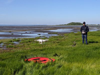
Hatfield undertook extensive baseline studies of fish and fish habitat, waterfowl, shorebirds, shellfish, foreshore vegetation and biofilm around Mud Bay, the Serpentine River, and the Nicomekl River. Study designs for respective baseline surveys were developed and field programs executed in terrestrial, freshwater, estuarine, and marine environments. Part of the baseline work involved drone flights over Mud Bay and the Serpentine River to quantify and document different marine habitat types (i.e., saltmarsh), for use in the Fisheries Act authorization applications for the projects.

Federal and provincial fish and infauna collection permits (DFO, Wildlife Management Areas) were applied for and issued for Mud Bay and the lower Serpentine River. A seasonal fish community survey was conducted over three seasons with the use of beach seine and minnow traps between the existing Serpentine sea dam and the marine environment. Surveys were conducted to capture information gaps to help inform provincial (Water Sustainability Act) and federal (Fisheries Act) application prerequisites.

Bird surveys were completed in Mud Bay during spring 2020 to document the distribution and abundance of shorebirds and waterfowl and assess the relative importance of the area with regards to biofilm. Additional surveys (e.g., point counts, stick nest scans, stand watches, visual encounters, plots) were completed at the four project sites in the summer of 2020 to document wildlife (e.g., songbirds, raptors, incidental detections of herptiles and invertebrates), vegetation, and habitat features.

Hatfield is supporting Indigenous and public engagement and managing archaeological assessments, including the development of an Ancestral Remains Policy in collaboration with the City of Surrey and Indigenous groups.


City of Surrey Coastal Flood Adaptation Strategy (CFAS) – Environmental Assessment Exemption

December 20, 2023 by

Find out more about our services from our team of technical experts

Connect With Us
  • Home
  • About
  • Projects
  • News
  • Careers
  • Contact
  • Agent Orange

Sectors

  • Forestry
  • Infrastructure
  • International Development
  • Marine
  • Mining & Exploration
  • Oil & Gas
  • Pulp & Paper
  • Renewable Energy

Services

  • WATER
  • Effects Monitoring & Ecotoxicology
  • Fish & Fish Habitat
  • Hydrogeology
  • Hydrology
  • Marine Ecology
  • Marine & Coastal Infrastructure
  • Regulatory Permitting
  • LAND
  • Forest Management
  • Infrastructure Development
  • Regulatory Permitting
  • Terrestrial Ecology
  • PEOPLE
  • Climate Change
  • Community Health & Wellbeing
  • Indigenous Relations
  • Socio-Economics
  • TECHNOLOGY
  • AI and Computer Vision
  • Data Analytics
  • GIS & Mapping
  • Remote Sensing
Copyright © Hatfield Consultants
  • Terms & Conditions
  • Privacy Policy
  • About
    ▼
    • At A Glance
    • Management Team
    • Board of Directors & Ownership
    • Our History
    • Corporate Social Responsibility
    • Quality Management
    • Health & Safety
    • Environmental Policy
    • Indigenous Relationships
    • Regions
      ▼
      • Canada
      • Indonesia
      • Africa
  • Services
    ▼
    • Water
      ▼
      • Effects Monitoring & Ecotoxicology
      • Fish & Fish Habitat
      • Hydrogeology
      • Hydrology
      • Marine Ecology
      • Marine & Coastal Infrastructure
      • Regulatory Permitting
    • Land
      ▼
      • Forest Management
      • Infrastructure Development
      • Regulatory Permitting
      • Terrestrial Ecology
    • People
      ▼
      • Climate Change
      • Community Health & Wellbeing
      • Indigenous Relations
      • Socio-Economics
    • Technology
      ▼
      • AI & Computer Vision
      • Data Analytics
      • GIS & Mapping
      • Remote Sensing
  • Sectors
    ▼
    • Forestry
    • Infrastructure
    • International Development
    • Marine
    • Mining & Exploration
    • Oil & Gas
    • Pulp & Paper
    • Renewable Energy
  • Projects
  • News
  • Careers
    ▼
    • Careers at Hatfield
    • Current Opportunities
    • Why Work at Hatfield?
  • Contact