• About
    • At A Glance
    • Management Team
    • Board of Directors & Ownership
    • Our History
    • Corporate Social Responsibility
    • Quality Management
    • Health & Safety
    • Environmental Policy
    • Indigenous Relationships
    • Regions
      • Canada
      • Indonesia
      • Africa
  • Services
    • Water
      • Effects Monitoring & Ecotoxicology
      • Fish & Fish Habitat
      • Hydrogeology
      • Hydrology
      • Marine Ecology
      • Marine & Coastal Infrastructure
      • Regulatory Permitting
    • Land
      • Forest Management
      • Infrastructure Development
      • Regulatory Permitting
      • Terrestrial Ecology
    • People
      • Climate Change
      • Community Health & Wellbeing
      • Indigenous Relations
      • Socio-Economics
    • Technology
      • AI & Computer Vision
      • Data Analytics
      • GIS & Mapping
      • Remote Sensing
  • Sectors
    • Forestry
    • Infrastructure
    • International Development
    • Marine
    • Mining & Exploration
    • Oil & Gas
    • Pulp & Paper
    • Renewable Energy
  • Projects
  • News
  • Careers
    • Careers at Hatfield
    • Current Opportunities
    • Why Work at Hatfield?
  • Contact

Bow River Aquifer Wellhead Protection Update and GWUDI Assessment

You are here: Home / Projects / Bow River Aquifer Wellhead Protection Update and GWUDI Assessment

Bow River Aquifer Wellhead Protection Update and GWUDI Assessment

Client:

Town of Canmore

Location:

Town of Canmore, Alberta, Canada

Dates:

June 2022 – December 2023

Background:

The Town had the following main project objectives:

  • Update the existing (1999) wellhead protection plan for the Town groundwater supply wells installed in the Bow River aquifer.
  • Define risks to aquifer contamination within the capture zone, considering current and future land uses, and with a particular emphasis on stormwater management within the travel time areas.
  • Carry out a ‘groundwater under the direct influence of surface water’ (GWUDI) assessment.

Services Provided:

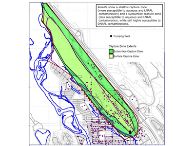
Groundwater Modelling: Hatfield provided hydrogeological expertise in conceptualizing, constructing and calibrating a MODFLOW-NWT numerical groundwater flow model of the Bow River aquifer. We emphasized the significance of representing interaction of water supply well operation in deeper portions of the aquifer with shallow groundwater and the Bow River. The calibrated groundwater model was used to define source well capture zones and travel times using MODPATH particle tracking simulations.  We conducted sensitivity analyses to assess uncertainty in capture zone extents and travel time calculations. Our considerations included factors such as aquifer properties, seasonality, short-term variations in well operations, and potential future pumping increases.

Wellhead protection plan update:  Groundwater times of travel within the capture zone to the water supply wells were defined. Aquifer contamination concerns within the capture zone were evaluated, considering Town permitted land uses, and with an additional emphasis on stormwater management (dry wells that discharge into the aquifer). The potential for aquifer contamination to reach the town supply wells was evaluated based on updated understanding of groundwater migration pathways.

GWUDI determination:  The groundwater under the direct influence of surface water determination was based on combined results from groundwater modelling (travel time analysis for groundwater migrating from surface to the supply wells) and microscopic particulate analysis (MPA). Both Town water supply wells were deemed non-GWUDI with, supported by these lines of evidence.

Bow River Aquifer Wellhead Protection Update and GWUDI Assessment

May 13, 2023 by

Find out more about our services from our team of technical experts

Connect With Us
  • Home
  • About
  • Projects
  • News
  • Careers
  • Contact
  • Agent Orange

Sectors

  • Forestry
  • Infrastructure
  • International Development
  • Marine
  • Mining & Exploration
  • Oil & Gas
  • Pulp & Paper
  • Renewable Energy

Services

  • WATER
  • Effects Monitoring & Ecotoxicology
  • Fish & Fish Habitat
  • Hydrogeology
  • Hydrology
  • Marine Ecology
  • Marine & Coastal Infrastructure
  • Regulatory Permitting
  • LAND
  • Forest Management
  • Infrastructure Development
  • Regulatory Permitting
  • Terrestrial Ecology
  • PEOPLE
  • Climate Change
  • Community Health & Wellbeing
  • Indigenous Relations
  • Socio-Economics
  • TECHNOLOGY
  • AI and Computer Vision
  • Data Analytics
  • GIS & Mapping
  • Remote Sensing
Copyright © Hatfield Consultants
  • Terms & Conditions
  • Privacy Policy
  • About
    ▼
    • At A Glance
    • Management Team
    • Board of Directors & Ownership
    • Our History
    • Corporate Social Responsibility
    • Quality Management
    • Health & Safety
    • Environmental Policy
    • Indigenous Relationships
    • Regions
      ▼
      • Canada
      • Indonesia
      • Africa
  • Services
    ▼
    • Water
      ▼
      • Effects Monitoring & Ecotoxicology
      • Fish & Fish Habitat
      • Hydrogeology
      • Hydrology
      • Marine Ecology
      • Marine & Coastal Infrastructure
      • Regulatory Permitting
    • Land
      ▼
      • Forest Management
      • Infrastructure Development
      • Regulatory Permitting
      • Terrestrial Ecology
    • People
      ▼
      • Climate Change
      • Community Health & Wellbeing
      • Indigenous Relations
      • Socio-Economics
    • Technology
      ▼
      • AI & Computer Vision
      • Data Analytics
      • GIS & Mapping
      • Remote Sensing
  • Sectors
    ▼
    • Forestry
    • Infrastructure
    • International Development
    • Marine
    • Mining & Exploration
    • Oil & Gas
    • Pulp & Paper
    • Renewable Energy
  • Projects
  • News
  • Careers
    ▼
    • Careers at Hatfield
    • Current Opportunities
    • Why Work at Hatfield?
  • Contact