• About
    • At A Glance
    • Management Team
    • Board of Directors & Ownership
    • Our History
    • Corporate Social Responsibility
    • Quality Management
    • Health & Safety
    • Environmental Policy
    • Indigenous Relationships
    • Regions
      • Canada
      • Indonesia
      • Africa
  • Services
    • Water
      • Effects Monitoring & Ecotoxicology
      • Fish & Fish Habitat
      • Hydrogeology
      • Hydrology
      • Marine Ecology
      • Marine & Coastal Infrastructure
      • Regulatory Permitting
    • Land
      • Forest Management
      • Infrastructure Development
      • Regulatory Permitting
      • Terrestrial Ecology
    • People
      • Climate Change
      • Community Health & Wellbeing
      • Indigenous Relations
      • Socio-Economics
    • Technology
      • AI & Computer Vision
      • Data Analytics
      • GIS & Mapping
      • Remote Sensing
  • Sectors
    • Forestry
    • Infrastructure
    • International Development
    • Marine
    • Mining & Exploration
    • Oil & Gas
    • Pulp & Paper
    • Renewable Energy
  • Projects
  • News
  • Careers
    • Careers at Hatfield
    • Current Opportunities
    • Why Work at Hatfield?
  • Contact

Hatfield Consultants Africa conducts SecureWatch satellite training for the Government of Botswana’s Land Boards

You are here: Home / News / Hatfield Consultants Africa conducts SecureWatch satellite training for the Government of Botswana’s Land Boards

Hatfield Consultants Africa conducts SecureWatch satellite training for the Government of Botswana’s Land Boards

Jul 12, 2021

Hatfield Consultants Africa (HCA) provides critical satellite image services in Botswana. As a Maxar partner, we provide the most comprehensive suite of commercial satellite imagery available, including SecureWatch®, a cloud-based subscription service for secure and timely access to Maxar’s satellite imagery.

On May 25, 2021, Hatfield Consultants Africa conducted its first virtual SecureWatch training to the Land Boards with over 20 attendees. Land use in Botswana is managed by a network of Land Boards, and the training introduced satellite imagery and SecureWatch® as an important new technology for land use management.

The training introduced the participants to SecureWatch and how they can integrate it into their day-to-day business. The participants learned about the Vivid 3.0 Mosaic of Botswana, a high resolution, high-accuracy mosaic of up-to-date images, as well as how to load satellite imagery into ArcMap, the Botswana custom map projections, how to work with SecureWatch in Esri ArcMap software, and how to use the SecureWatch web application.

We will continue to provide SecureWatch training on an ongoing basis and looks forward to sharing more on satellite image technology.
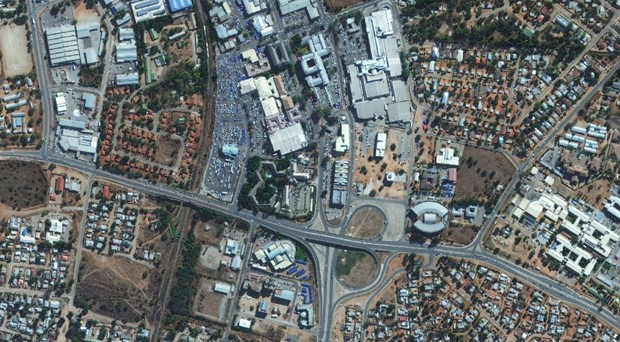
Hatfield Consultants Africa conducts SecureWatch satellite training for the Government of Botswana’s Land Boardsl

Hatfield Consultants Africa conducts SecureWatch satellite training for the Government of Botswana’s Land Boards

July 12, 2021 by

Interested in joining our innovative team?

Career Opportunities
  • Home
  • About
  • Projects
  • News
  • Careers
  • Contact
  • Agent Orange

Sectors

  • Forestry
  • Infrastructure
  • International Development
  • Marine
  • Mining & Exploration
  • Oil & Gas
  • Pulp & Paper
  • Renewable Energy

Services

  • WATER
  • Effects Monitoring & Ecotoxicology
  • Fish & Fish Habitat
  • Hydrogeology
  • Hydrology
  • Marine Ecology
  • Marine & Coastal Infrastructure
  • Regulatory Permitting
  • LAND
  • Forest Management
  • Infrastructure Development
  • Regulatory Permitting
  • Terrestrial Ecology
  • PEOPLE
  • Climate Change
  • Community Health & Wellbeing
  • Indigenous Relations
  • Socio-Economics
  • TECHNOLOGY
  • AI and Computer Vision
  • Data Analytics
  • GIS & Mapping
  • Remote Sensing
Copyright © Hatfield Consultants
  • Terms & Conditions
  • Privacy Policy
  • About
    ▼
    • At A Glance
    • Management Team
    • Board of Directors & Ownership
    • Our History
    • Corporate Social Responsibility
    • Quality Management
    • Health & Safety
    • Environmental Policy
    • Indigenous Relationships
    • Regions
      ▼
      • Canada
      • Indonesia
      • Africa
  • Services
    ▼
    • Water
      ▼
      • Effects Monitoring & Ecotoxicology
      • Fish & Fish Habitat
      • Hydrogeology
      • Hydrology
      • Marine Ecology
      • Marine & Coastal Infrastructure
      • Regulatory Permitting
    • Land
      ▼
      • Forest Management
      • Infrastructure Development
      • Regulatory Permitting
      • Terrestrial Ecology
    • People
      ▼
      • Climate Change
      • Community Health & Wellbeing
      • Indigenous Relations
      • Socio-Economics
    • Technology
      ▼
      • AI & Computer Vision
      • Data Analytics
      • GIS & Mapping
      • Remote Sensing
  • Sectors
    ▼
    • Forestry
    • Infrastructure
    • International Development
    • Marine
    • Mining & Exploration
    • Oil & Gas
    • Pulp & Paper
    • Renewable Energy
  • Projects
  • News
  • Careers
    ▼
    • Careers at Hatfield
    • Current Opportunities
    • Why Work at Hatfield?
  • Contact