Hatfield to provide GeoEye-1 satellite imagery to Canadian government department
Aug 24, 2010
On July 28, Hatfield was awarded a standing offer to become the sole provider of panchromatic GeoEye-1 satellite imagery to the Natural Resources Canada – Canadian Forest Service (CFS) National Forest Inventory (NFI) Program over the next two years.
As part of the standing offer, as many as 300 images of NFI plots across Northern Canada may be provided, which is supported by an existing official global reseller agreement for GeoEye, established between Hatfield and GeoEye Inc. in 2007. The geomatics team at Hatfield has the required experience to utilize the tools and procedures provided by GeoEye to acquire new and archived high-resolution satellite imagery to support the Government of Canada in this program of work.
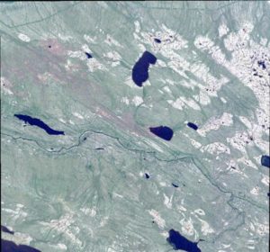
The geographic location of this image is west of Great Bear Lake in the Northwest Territories. This represents a 1m panchromatic ortho-corrected image collected by the GeoEye-1 satellite on July 10, 2010. Image courtesy of GeoEye.
Hatfield is an official reseller of GeoEye products and services in Canada and Indonesia, including GeoEye-1 and Ikonos satellite data and MJ Harden aerial photography. In Indonesia, we are also an official reseller of SPOT, TerraSAR-X Services, RapidEye, Kompsat and Formosat satellite image data. We have access to, and experience with, Landsat, ENVISAT, ERS, Quickbird/WorldView, and ALOS PALSAR. In addition to existing archives of these numerous sensors, new satellites are being launched every year.
At Hatfield, we use the latest geographic information, remote-sensing, and web-development technologies to implement innovative, appropriate, and user-driven solutions and products for environmental applications around the world. Our geographic information system (GIS) and remote-sensing (RS) products and services complement our traditional environmental assessment and monitoring services.
For more information, please contact us:
Simon Hughes
Manager, Geomatics Department
HATFIELD CONSULTANTS PARTNERSHIP
E-mail: hcp@hatfieldgroup.com
Tel.: +1 604 926 3261
Toll-Free: 1 866 926 3261