• About
    • At A Glance
    • Management Team
    • Board of Directors & Ownership
    • Our History
    • Corporate Social Responsibility
    • Quality Management
    • Health & Safety
    • Environmental Policy
    • Indigenous Relationships
    • Regions
      • Canada
      • Indonesia
      • Africa
  • Services
    • Water
      • Effects Monitoring & Ecotoxicology
      • Fish & Fish Habitat
      • Hydrogeology
      • Hydrology
      • Marine Ecology
      • Marine & Coastal Infrastructure
      • Regulatory Permitting
    • Land
      • Forest Management
      • Infrastructure Development
      • Regulatory Permitting
      • Terrestrial Ecology
    • People
      • Climate Change
      • Community Health & Wellbeing
      • Indigenous Relations
      • Socio-Economics
    • Technology
      • AI & Computer Vision
      • Data Analytics
      • GIS & Mapping
      • Remote Sensing
  • Sectors
    • Forestry
    • Infrastructure
    • International Development
    • Marine
    • Mining & Exploration
    • Oil & Gas
    • Pulp & Paper
    • Renewable Energy
  • Projects
  • News
  • Careers
    • Careers at Hatfield
    • Current Opportunities
    • Why Work at Hatfield?
  • Contact

Hatfield study for Montreal Port Authority identifies how earth observation can support environmental monitoring

You are here: Home / News / Hatfield study for Montreal Port Authority identifies how earth observation can support environmental monitoring

Hatfield study for Montreal Port Authority identifies how earth observation can support environmental monitoring

Oct 11, 2018

Hatfield supported the Montreal Port Authority (MPA), Public Works and Government Services Canada (PWGSC), and the Canadian Space Agency (CSA) to review the feasibility of using Earth Observation technology for environmental monitoring during the construction and operation of a proposed container terminal.

To handle the growth of the container market in Quebec and Eastern Canada, the MPA plans to develop a container terminal at Contrecœur, 40 km east of Montreal. Construction, planned to begin in 2020, will include dredging of approximately 840,000 m3 of sediment to create an approach and mooring area opposite the future 675 m long wharf. Hatfield worked with Arctus Inc to review the feasibility of using remote sensing technology for the monitoring of a range of environmental parameters to support management and protection of riparian ecosystems during the construction and operation of the terminal. The study was featured this month in the Quebec remote sensing association (Association québécoise de télédétection) newsletter (in French).

The study confirmed that current Earth Observation technologies are cost-effective and could enhance and extend required environmental monitoring programs. The key requirements were:

  • total suspended solids monitoring on a daily basis during dredging (see Fig. 1)
  • wetland assessment downstream of the proposed port
  • seagrass bed assessment
  • coastline monitoring of erosion and deposition areas
  • land cover and land use mapping

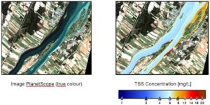
Fig.1 Example of TSS concentration in the St. Lawrence River mapped using a PlanetScope image acquired on 01 October, 2017

For more information about application of remote sensing technologies for environmental monitoring, please review our remote sensing services.

For more information, please contact:

Andy Dean
Senior Partner
HATFIELD CONSULTANTS PARTNERSHIP

E-mail: hcp@hatfieldgroup.com
Tel.: +1-604-926-3261
Toll-Free: +1-866-926-3261

Hatfield study for Montreal Port Authority identifies how earth observation can support environmental monitoring

October 11, 2018 by

Interested in joining our innovative team?

Career Opportunities
  • Home
  • About
  • Projects
  • News
  • Careers
  • Contact
  • Agent Orange

Sectors

  • Forestry
  • Infrastructure
  • International Development
  • Marine
  • Mining & Exploration
  • Oil & Gas
  • Pulp & Paper
  • Renewable Energy

Services

  • WATER
  • Effects Monitoring & Ecotoxicology
  • Fish & Fish Habitat
  • Hydrogeology
  • Hydrology
  • Marine Ecology
  • Marine & Coastal Infrastructure
  • Regulatory Permitting
  • LAND
  • Forest Management
  • Infrastructure Development
  • Regulatory Permitting
  • Terrestrial Ecology
  • PEOPLE
  • Climate Change
  • Community Health & Wellbeing
  • Indigenous Relations
  • Socio-Economics
  • TECHNOLOGY
  • AI and Computer Vision
  • Data Analytics
  • GIS & Mapping
  • Remote Sensing
Copyright © Hatfield Consultants
  • Terms & Conditions
  • Privacy Policy
  • About
    ▼
    • At A Glance
    • Management Team
    • Board of Directors & Ownership
    • Our History
    • Corporate Social Responsibility
    • Quality Management
    • Health & Safety
    • Environmental Policy
    • Indigenous Relationships
    • Regions
      ▼
      • Canada
      • Indonesia
      • Africa
  • Services
    ▼
    • Water
      ▼
      • Effects Monitoring & Ecotoxicology
      • Fish & Fish Habitat
      • Hydrogeology
      • Hydrology
      • Marine Ecology
      • Marine & Coastal Infrastructure
      • Regulatory Permitting
    • Land
      ▼
      • Forest Management
      • Infrastructure Development
      • Regulatory Permitting
      • Terrestrial Ecology
    • People
      ▼
      • Climate Change
      • Community Health & Wellbeing
      • Indigenous Relations
      • Socio-Economics
    • Technology
      ▼
      • AI & Computer Vision
      • Data Analytics
      • GIS & Mapping
      • Remote Sensing
  • Sectors
    ▼
    • Forestry
    • Infrastructure
    • International Development
    • Marine
    • Mining & Exploration
    • Oil & Gas
    • Pulp & Paper
    • Renewable Energy
  • Projects
  • News
  • Careers
    ▼
    • Careers at Hatfield
    • Current Opportunities
    • Why Work at Hatfield?
  • Contact