• About
    • At A Glance
    • Management Team
    • Board of Directors & Ownership
    • Our History
    • Corporate Social Responsibility
    • Quality Management
    • Health & Safety
    • Environmental Policy
    • Indigenous Relationships
    • Regions
      • Canada
      • Indonesia
      • Africa
  • Services
    • Water
      • Effects Monitoring & Ecotoxicology
      • Fish & Fish Habitat
      • Hydrogeology
      • Hydrology
      • Marine Ecology
      • Marine & Coastal Infrastructure
      • Regulatory Permitting
    • Land
      • Forest Management
      • Infrastructure Development
      • Regulatory Permitting
      • Terrestrial Ecology
    • People
      • Climate Change
      • Community Health & Wellbeing
      • Indigenous Relations
      • Socio-Economics
    • Technology
      • AI & Computer Vision
      • Data Analytics
      • GIS & Mapping
      • Remote Sensing
  • Sectors
    • Forestry
    • Infrastructure
    • International Development
    • Marine
    • Mining & Exploration
    • Oil & Gas
    • Pulp & Paper
    • Renewable Energy
  • Projects
  • News
  • Careers
    • Careers at Hatfield
    • Current Opportunities
    • Why Work at Hatfield?
  • Contact

smartHarbour – Monitoring Eelgrass, Terrestrial Vegetation, Wetlands, and Shoreline Erosion

You are here: Home / Projects / smartHarbour – Monitoring Eelgrass, Terrestrial Vegetation, Wetlands, and Shoreline Erosion

smartHarbour – Monitoring Eelgrass, Terrestrial Vegetation, Wetlands, and Shoreline Erosion

Client

Canadian Space Agency/ Public Services and Procurement Canada/ Montreal Port Authority

Location

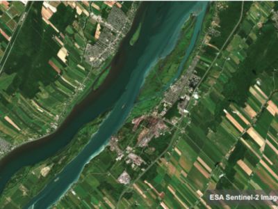
Contrecœur, Quebec; and St. Lawrence River

Project Duration

July 2023 – Ongoing

Background

Public Services and Procurement Canada (PSPC), the Canadian Space Agency (CSA), and Montreal Port Authority have developed the smartHarbour initiative to develop satellite Earth observation monitoring solutions for the St. Lawrence River as part of the Contrecoeur port terminal expansion. The solutions will contribute to “a follow-up program to verify the accuracy of the environmental assessment and determine the effectiveness of the mitigation measures […] and augment the information collected in the field with additional information obtained by means of Earth observation technologies.”

Services Provided

Hatfield leads a multi-disciplinary team of scientists from the private sector, academia, and a non-government organization to develop terrestrial environmental monitoring applications, including mapping of terrestrial vegetation, wetlands, shoreline delineation and erosion trends, and submerged aquatic vegetation.

Hatfield’s team comprises:

  • Ducks Unlimited Canada (DUC) – experts and leaders in wetland conservation.
  • Arctus – a private research and development (R&D) company specializing in optical remote sensing of aquatic environments, from lakes to oceans.
  • Andrea Bertolo, Université du Québec à Trois-Rivières (UQTR) – professor in the Department of Environmental Sciences at UQTR whose research focuses on aquatic vegetation beds, with direct experience along the St. Lawrence River.
  • Maycira Costa, University of Victoria (UVic) – professor whose research is focused on methods to make more effective use of remote sensing data for understanding and monitoring biophysical processes in ocean waters and wetlands.

smartHarbour – Monitoring Eelgrass, Terrestrial Vegetation, Wetlands, and Shoreline Erosion

May 11, 2025 by

Find out more about our services from our team of technical experts

Connect With Us
  • Home
  • About
  • Projects
  • News
  • Careers
  • Contact
  • Agent Orange

Sectors

  • Forestry
  • Infrastructure
  • International Development
  • Marine
  • Mining & Exploration
  • Oil & Gas
  • Pulp & Paper
  • Renewable Energy

Services

  • WATER
  • Effects Monitoring & Ecotoxicology
  • Fish & Fish Habitat
  • Hydrogeology
  • Hydrology
  • Marine Ecology
  • Marine & Coastal Infrastructure
  • Regulatory Permitting
  • LAND
  • Forest Management
  • Infrastructure Development
  • Regulatory Permitting
  • Terrestrial Ecology
  • PEOPLE
  • Climate Change
  • Community Health & Wellbeing
  • Indigenous Relations
  • Socio-Economics
  • TECHNOLOGY
  • AI and Computer Vision
  • Data Analytics
  • GIS & Mapping
  • Remote Sensing
Copyright © Hatfield Consultants
  • Terms & Conditions
  • Privacy Policy
  • About
    ▼
    • At A Glance
    • Management Team
    • Board of Directors & Ownership
    • Our History
    • Corporate Social Responsibility
    • Quality Management
    • Health & Safety
    • Environmental Policy
    • Indigenous Relationships
    • Regions
      ▼
      • Canada
      • Indonesia
      • Africa
  • Services
    ▼
    • Water
      ▼
      • Effects Monitoring & Ecotoxicology
      • Fish & Fish Habitat
      • Hydrogeology
      • Hydrology
      • Marine Ecology
      • Marine & Coastal Infrastructure
      • Regulatory Permitting
    • Land
      ▼
      • Forest Management
      • Infrastructure Development
      • Regulatory Permitting
      • Terrestrial Ecology
    • People
      ▼
      • Climate Change
      • Community Health & Wellbeing
      • Indigenous Relations
      • Socio-Economics
    • Technology
      ▼
      • AI & Computer Vision
      • Data Analytics
      • GIS & Mapping
      • Remote Sensing
  • Sectors
    ▼
    • Forestry
    • Infrastructure
    • International Development
    • Marine
    • Mining & Exploration
    • Oil & Gas
    • Pulp & Paper
    • Renewable Energy
  • Projects
  • News
  • Careers
    ▼
    • Careers at Hatfield
    • Current Opportunities
    • Why Work at Hatfield?
  • Contact