• About
    • At A Glance
    • Management Team
    • Board of Directors & Ownership
    • Our History
    • Corporate Social Responsibility
    • Quality Management
    • Health & Safety
    • Environmental Policy
    • Indigenous Relationships
    • Regions
      • Canada
      • Indonesia
      • Africa
  • Services
    • Water
      • Effects Monitoring & Ecotoxicology
      • Fish & Fish Habitat
      • Hydrogeology
      • Hydrology
      • Marine Ecology
      • Marine & Coastal Infrastructure
      • Regulatory Permitting
    • Land
      • Forest Management
      • Infrastructure Development
      • Regulatory Permitting
      • Terrestrial Ecology
    • People
      • Climate Change
      • Community Health & Wellbeing
      • Indigenous Relations
      • Socio-Economics
    • Technology
      • AI & Computer Vision
      • Data Analytics
      • GIS & Mapping
      • Remote Sensing
  • Sectors
    • Forestry
    • Infrastructure
    • International Development
    • Marine
    • Mining & Exploration
    • Oil & Gas
    • Pulp & Paper
    • Renewable Energy
  • Projects
  • News
  • Careers
    • Careers at Hatfield
    • Current Opportunities
    • Why Work at Hatfield?
  • Contact

Madagascar National Mangrove Mapping from 2019 to 2023 for Pêche Côtière Durable Phase II

You are here: Home / Projects / Madagascar National Mangrove Mapping from 2019 to 2023 for Pêche Côtière Durable Phase II

Madagascar National Mangrove Mapping from 2019 to 2023 for Pêche Côtière Durable Phase II

Client(s):

Madagascar National Parks / AHT Group

Location:

Madagascar

Dates:

January 2020 – February 2024

Background:

Madagascar National Parks (MNP) leads the implementation of Pêche Côtière Durable Phase II (PCD II), collaborating closely with national and international NGOs already established in the area concerned by the project. This collaborative effort ensures the successful execution of five regional sub-projects. The overarching goal is to achieve sustainable management of coastal natural resources, with a specific focus on mangrove ecosystems and the vital services they provide to local communities and populations.

The specific objectives are:

  • For local communities to effectively contribute to, and to participate in sustainable EbA (Ecosystem-based Approaches) to coastal natural resource management,
  • Thereby improving their socio-economic livelihoods.

Effective Monitoring and Evaluation (MES) is critical to achieving the project’s objectives. This includes ecological monitoring, which assesses the health of ecosystems and biodiversity. Satellite Earth Observation plays a vital role in this process by enabling systematic mapping of mangroves.

Services Provided:

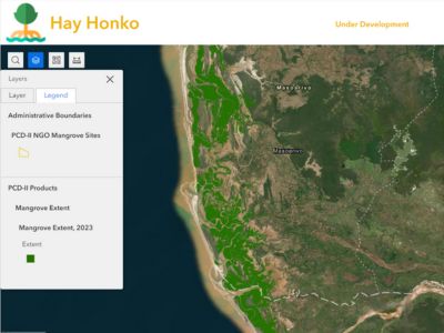
Hatfield’s experts developed machine learning models using satellite Earth Observation data to generate mangrove extent, height, and canopy closure products between 2019 and 2023 for the entire western and northeastern coastal zone of Madagascar.

Hatfield built a web portal and web map, so that users can visualize the mangrove extent, canopy height, and canopy closure data and can view charts of mangrove extent and gain/loss for administrative units and PCD II project areas.

Madagascar National Mangrove Mapping from 2019 to 2023 for Pêche Côtière Durable Phase II

February 6, 2024 by

Find out more about our services from our team of technical experts

Connect With Us
  • Home
  • About
  • Projects
  • News
  • Careers
  • Contact
  • Agent Orange

Sectors

  • Forestry
  • Infrastructure
  • International Development
  • Marine
  • Mining & Exploration
  • Oil & Gas
  • Pulp & Paper
  • Renewable Energy

Services

  • WATER
  • Effects Monitoring & Ecotoxicology
  • Fish & Fish Habitat
  • Hydrogeology
  • Hydrology
  • Marine Ecology
  • Marine & Coastal Infrastructure
  • Regulatory Permitting
  • LAND
  • Forest Management
  • Infrastructure Development
  • Regulatory Permitting
  • Terrestrial Ecology
  • PEOPLE
  • Climate Change
  • Community Health & Wellbeing
  • Indigenous Relations
  • Socio-Economics
  • TECHNOLOGY
  • AI and Computer Vision
  • Data Analytics
  • GIS & Mapping
  • Remote Sensing
Copyright © Hatfield Consultants
  • Terms & Conditions
  • Privacy Policy
  • About
    ▼
    • At A Glance
    • Management Team
    • Board of Directors & Ownership
    • Our History
    • Corporate Social Responsibility
    • Quality Management
    • Health & Safety
    • Environmental Policy
    • Indigenous Relationships
    • Regions
      ▼
      • Canada
      • Indonesia
      • Africa
  • Services
    ▼
    • Water
      ▼
      • Effects Monitoring & Ecotoxicology
      • Fish & Fish Habitat
      • Hydrogeology
      • Hydrology
      • Marine Ecology
      • Marine & Coastal Infrastructure
      • Regulatory Permitting
    • Land
      ▼
      • Forest Management
      • Infrastructure Development
      • Regulatory Permitting
      • Terrestrial Ecology
    • People
      ▼
      • Climate Change
      • Community Health & Wellbeing
      • Indigenous Relations
      • Socio-Economics
    • Technology
      ▼
      • AI & Computer Vision
      • Data Analytics
      • GIS & Mapping
      • Remote Sensing
  • Sectors
    ▼
    • Forestry
    • Infrastructure
    • International Development
    • Marine
    • Mining & Exploration
    • Oil & Gas
    • Pulp & Paper
    • Renewable Energy
  • Projects
  • News
  • Careers
    ▼
    • Careers at Hatfield
    • Current Opportunities
    • Why Work at Hatfield?
  • Contact