• About
    • At A Glance
    • Management Team
    • Board of Directors & Ownership
    • Our History
    • Corporate Social Responsibility
    • Quality Management
    • Health & Safety
    • Environmental Policy
    • Indigenous Relationships
    • Regions
      • Canada
      • Indonesia
      • Africa
  • Services
    • Water
      • Effects Monitoring & Ecotoxicology
      • Fish & Fish Habitat
      • Hydrogeology
      • Hydrology
      • Marine Ecology
      • Marine & Coastal Infrastructure
      • Regulatory Permitting
    • Land
      • Forest Management
      • Infrastructure Development
      • Regulatory Permitting
      • Terrestrial Ecology
    • People
      • Climate Change
      • Community Health & Wellbeing
      • Indigenous Relations
      • Socio-Economics
    • Technology
      • AI & Computer Vision
      • Data Analytics
      • GIS & Mapping
      • Remote Sensing
  • Sectors
    • Forestry
    • Infrastructure
    • International Development
    • Marine
    • Mining & Exploration
    • Oil & Gas
    • Pulp & Paper
    • Renewable Energy
  • Projects
  • News
  • Careers
    • Careers at Hatfield
    • Current Opportunities
    • Why Work at Hatfield?
  • Contact

Leaf Area Index Modelling in Northern Alberta

You are here: Home / Projects / Leaf Area Index Modelling in Northern Alberta

Leaf Area Index Modelling in Northern Alberta

Client

Not disclosed

Location

Northern Alberta

Project Duration

June 2018 – December 2019

Background

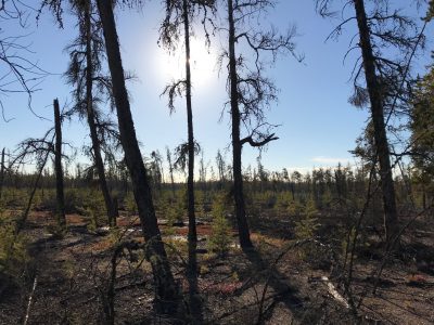
Leaf Area Index (LAI) is a measure of the amount of leaf area relative to the ground area, and is an important vegetation parameter driving net primary production, water and nutrient use, and carbon balance. Many resource development companies seek to understand and manage the water balance in their areas of operation. LAI information, covering large spatial areas and updated several times per year during the growing season, is a useful input to hydrological models.

Services Provided

Hatfield developed a machine learning model, calibrated by in-situ measurements, based on optical and radar satellite EO data to estimate LAI of boreal forest ecosystems in Northern Alberta. The purpose of the model is to provide a cost-efficient and consistent method to estimate LAI over the snow-free / leaf-on season for any given year. The “Optical-SAR” model developed by Hatfield shows the ability to predict LAI monthly while capturing the fine spatial variability in LAI. Integration of Sentinel-2 data with Sentinel-1 data leverages the strengths of both satellite systems, with multi-spectral data sensitive to the photosynthetic components of the canopy and radar data sensitive to the structural components, providing additional information under the canopy given it has more penetration capability.

Hatfield compared these Sentinel-based LAI estimates to the broad-scale LAI estimates from MODIS, with clear improvements in the data provided by the Sentinel model, which better captures the LAI across the heterogeneous land cover in the boreal forest region.

Leaf Area Index Modelling in Northern Alberta

August 6, 2020 by

Find out more about our services from our team of technical experts

Connect With Us
  • Home
  • About
  • Projects
  • News
  • Careers
  • Contact
  • Agent Orange

Sectors

  • Forestry
  • Infrastructure
  • International Development
  • Marine
  • Mining & Exploration
  • Oil & Gas
  • Pulp & Paper
  • Renewable Energy

Services

  • WATER
  • Effects Monitoring & Ecotoxicology
  • Fish & Fish Habitat
  • Hydrogeology
  • Hydrology
  • Marine Ecology
  • Marine & Coastal Infrastructure
  • Regulatory Permitting
  • LAND
  • Forest Management
  • Infrastructure Development
  • Regulatory Permitting
  • Terrestrial Ecology
  • PEOPLE
  • Climate Change
  • Community Health & Wellbeing
  • Indigenous Relations
  • Socio-Economics
  • TECHNOLOGY
  • AI and Computer Vision
  • Data Analytics
  • GIS & Mapping
  • Remote Sensing
Copyright © Hatfield Consultants
  • Terms & Conditions
  • Privacy Policy
  • About
    ▼
    • At A Glance
    • Management Team
    • Board of Directors & Ownership
    • Our History
    • Corporate Social Responsibility
    • Quality Management
    • Health & Safety
    • Environmental Policy
    • Indigenous Relationships
    • Regions
      ▼
      • Canada
      • Indonesia
      • Africa
  • Services
    ▼
    • Water
      ▼
      • Effects Monitoring & Ecotoxicology
      • Fish & Fish Habitat
      • Hydrogeology
      • Hydrology
      • Marine Ecology
      • Marine & Coastal Infrastructure
      • Regulatory Permitting
    • Land
      ▼
      • Forest Management
      • Infrastructure Development
      • Regulatory Permitting
      • Terrestrial Ecology
    • People
      ▼
      • Climate Change
      • Community Health & Wellbeing
      • Indigenous Relations
      • Socio-Economics
    • Technology
      ▼
      • AI & Computer Vision
      • Data Analytics
      • GIS & Mapping
      • Remote Sensing
  • Sectors
    ▼
    • Forestry
    • Infrastructure
    • International Development
    • Marine
    • Mining & Exploration
    • Oil & Gas
    • Pulp & Paper
    • Renewable Energy
  • Projects
  • News
  • Careers
    ▼
    • Careers at Hatfield
    • Current Opportunities
    • Why Work at Hatfield?
  • Contact