• About
    • At A Glance
    • Management Team
    • Board of Directors & Ownership
    • Our History
    • Corporate Social Responsibility
    • Quality Management
    • Health & Safety
    • Environmental Policy
    • Indigenous Relationships
    • Regions
      • Canada
      • Indonesia
      • Africa
  • Services
    • Water
      • Effects Monitoring & Ecotoxicology
      • Fish & Fish Habitat
      • Hydrogeology
      • Hydrology
      • Marine Ecology
      • Marine & Coastal Infrastructure
      • Regulatory Permitting
    • Land
      • Forest Management
      • Infrastructure Development
      • Regulatory Permitting
      • Terrestrial Ecology
    • People
      • Climate Change
      • Community Health & Wellbeing
      • Indigenous Relations
      • Socio-Economics
    • Technology
      • AI & Computer Vision
      • Data Analytics
      • GIS & Mapping
      • Remote Sensing
  • Sectors
    • Forestry
    • Infrastructure
    • International Development
    • Marine
    • Mining & Exploration
    • Oil & Gas
    • Pulp & Paper
    • Renewable Energy
  • Projects
  • News
  • Careers
    • Careers at Hatfield
    • Current Opportunities
    • Why Work at Hatfield?
  • Contact

Forest Distribution Map for the Southern African Development Community (SADC) Region

You are here: Home / Projects / Forest Distribution Map for the Southern African Development Community (SADC) Region

Forest Distribution Map for the Southern African Development Community (SADC) Region

Client

Japan International Cooperation Agency (JICA) and Department of Forest and Range Resources, Botswana

Location

Gaborone, Botswana

Project Duration

2014 – 2019

Background

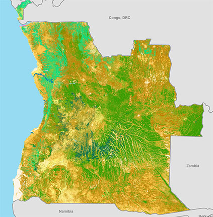
Hatfield was engaged by JICA to develop a satellite imagery-based forest distribution map for all 16 Southern African Development Community (SADC) Member States. Forest extent and distribution estimates will be used at a national level for forest management and carbon stock assessment reporting.

Services Provided

Hatfield Africa developed national Forest Inventory maps of all Member States using 30-metre resolution images acquired using the Landsat-8 Operational Land Imager for continental Member States, and 10-metre Sentinel-2A for Indian Ocean Island States. Services included satellite image acquisition, processing and analysis, stakeholder engagement and training of national forestry agency staff in basic and advanced remote sensing methods and approaches. Hatfield also provided training for technical representatives from each Member State to facilitate use of the datasets.

Forest Distribution Map for the Southern African Development Community (SADC) Region

May 31, 2019 by

Find out more about our services from our team of technical experts

Connect With Us
  • Home
  • About
  • Projects
  • News
  • Careers
  • Contact
  • Agent Orange

Sectors

  • Forestry
  • Infrastructure
  • International Development
  • Marine
  • Mining & Exploration
  • Oil & Gas
  • Pulp & Paper
  • Renewable Energy

Services

  • WATER
  • Effects Monitoring & Ecotoxicology
  • Fish & Fish Habitat
  • Hydrogeology
  • Hydrology
  • Marine Ecology
  • Marine & Coastal Infrastructure
  • Regulatory Permitting
  • LAND
  • Forest Management
  • Infrastructure Development
  • Regulatory Permitting
  • Terrestrial Ecology
  • PEOPLE
  • Climate Change
  • Community Health & Wellbeing
  • Indigenous Relations
  • Socio-Economics
  • TECHNOLOGY
  • AI and Computer Vision
  • Data Analytics
  • GIS & Mapping
  • Remote Sensing
Copyright © Hatfield Consultants
  • Terms & Conditions
  • Privacy Policy
  • About
    ▼
    • At A Glance
    • Management Team
    • Board of Directors & Ownership
    • Our History
    • Corporate Social Responsibility
    • Quality Management
    • Health & Safety
    • Environmental Policy
    • Indigenous Relationships
    • Regions
      ▼
      • Canada
      • Indonesia
      • Africa
  • Services
    ▼
    • Water
      ▼
      • Effects Monitoring & Ecotoxicology
      • Fish & Fish Habitat
      • Hydrogeology
      • Hydrology
      • Marine Ecology
      • Marine & Coastal Infrastructure
      • Regulatory Permitting
    • Land
      ▼
      • Forest Management
      • Infrastructure Development
      • Regulatory Permitting
      • Terrestrial Ecology
    • People
      ▼
      • Climate Change
      • Community Health & Wellbeing
      • Indigenous Relations
      • Socio-Economics
    • Technology
      ▼
      • AI & Computer Vision
      • Data Analytics
      • GIS & Mapping
      • Remote Sensing
  • Sectors
    ▼
    • Forestry
    • Infrastructure
    • International Development
    • Marine
    • Mining & Exploration
    • Oil & Gas
    • Pulp & Paper
    • Renewable Energy
  • Projects
  • News
  • Careers
    ▼
    • Careers at Hatfield
    • Current Opportunities
    • Why Work at Hatfield?
  • Contact