• About
    • At A Glance
    • Management Team
    • Board of Directors & Ownership
    • Our History
    • Corporate Social Responsibility
    • Quality Management
    • Health & Safety
    • Environmental Policy
    • Indigenous Relationships
    • Regions
      • Canada
      • Indonesia
      • Africa
  • Services
    • Water
      • Effects Monitoring & Ecotoxicology
      • Fish & Fish Habitat
      • Hydrogeology
      • Hydrology
      • Marine Ecology
      • Marine & Coastal Infrastructure
      • Regulatory Permitting
    • Land
      • Forest Management
      • Infrastructure Development
      • Regulatory Permitting
      • Terrestrial Ecology
    • People
      • Climate Change
      • Community Health & Wellbeing
      • Indigenous Relations
      • Socio-Economics
    • Technology
      • AI & Computer Vision
      • Data Analytics
      • GIS & Mapping
      • Remote Sensing
  • Sectors
    • Forestry
    • Infrastructure
    • International Development
    • Marine
    • Mining & Exploration
    • Oil & Gas
    • Pulp & Paper
    • Renewable Energy
  • Projects
  • News
  • Careers
    • Careers at Hatfield
    • Current Opportunities
    • Why Work at Hatfield?
  • Contact

User Needs Assessment and User Engagement Materials for the Canadian Geospatial Data Infrastructure

You are here: Home / Projects / User Needs Assessment and User Engagement Materials for the Canadian Geospatial Data Infrastructure

User Needs Assessment and User Engagement Materials for the Canadian Geospatial Data Infrastructure

Client

Natural Resources Canada (NRCan)

Location

Multiple

Project Duration

January 2018 – September 2021

Background

The Government of Canada has been promoting and facilitating user needs assessments (UNA) and user centered design (UCD) since GeoConnections Phase II, which ran from 2005 to 2010. GeoConnections is a national initiative designed to make spatial data and analysis as widely available as possible to help Canadian citizens, groups, businesses and communities manage the complex social, economic, cultural, and environmental issues of the 21st Century. The highly technical and specialized world of geospatial data and analysis and the almost infinite diversity of users’ issues and needs is highly complex.

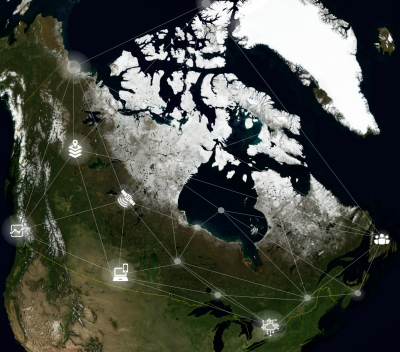
The project focused on conducting UNA and UCD for the Canadian Geospatial Data Infrastructure (CGDI) aimed at several Canadian stakeholders, the international Arctic community, and Indigenous peoples/communities/organizations across Canada and internationally. The objective of the project was to conceptualize, document, frame and develop detailed UNA and UCD studies in terms of data and services, standards, technologies, operational policies, Indigenous roles and relationships, and collaboration, leadership and governance. Subsequently, CGDI engagement and knowledge building materials were required.

Services Provided

Hatfield led the UNA and UCD study to research and detail the spatial data infrastructure (SDI) requirements of various communities: Canadian stakeholders (CGDI), the International Arctic community, and Indigenous communities (First Nations, Inuit, Métis). The resulting UNA provided a 2017-2018 landscape of existing and new users of the CGDI. The results helped understanding of the current requirements of dataset users and how to best add value to their CGDI experience while saving time and money. Additionally, the results guided the development, maintenance, evolution, and awareness of both SDIs.

Following the UNA and UCD study, the need for user engagement and knowledge building was addressed. Although the shift to open government data is very positive, the vast number of datasets available on the Government of Canada Open Data portal and provincial or territorial sites can be a barrier for novice users who struggle to access these datasets efficiently. To overcome this challenge, Hatfield demonstrated the concept of a CGDI analysis-ready data “Starter Kit” concept, which are curated sets of geospatial datasets and web services. The CGDI Starter Kits were created to help Canadians find, use, and share geospatial data by curating packages of data based on user needs. These kits are designed to be easily accessible and usable by new and novice GIS and data analytics users, with special attention to the needs of Indigenous Peoples (First Nations, Inuit, Métis).

In addition, engagement materials were developed to support Canadians to access and understand the CGDI. Hatfield developed a flysheet, cookbook, and use cases of the CGDI. It is important for national geospatial datasets to be accessible and usable to support users to address challenges and opportunities in environmental management, climate change, and sustainable development. Through fostering collaboration among users in these areas we will see real benefits to the Canadian people, environment, and economy.

User Needs Assessment and User Engagement Materials for the Canadian Geospatial Data Infrastructure

August 6, 2021 by

Find out more about our services from our team of technical experts

Connect With Us
  • Home
  • About
  • Projects
  • News
  • Careers
  • Contact
  • Agent Orange

Sectors

  • Forestry
  • Infrastructure
  • International Development
  • Marine
  • Mining & Exploration
  • Oil & Gas
  • Pulp & Paper
  • Renewable Energy

Services

  • WATER
  • Effects Monitoring & Ecotoxicology
  • Fish & Fish Habitat
  • Hydrogeology
  • Hydrology
  • Marine Ecology
  • Marine & Coastal Infrastructure
  • Regulatory Permitting
  • LAND
  • Forest Management
  • Infrastructure Development
  • Regulatory Permitting
  • Terrestrial Ecology
  • PEOPLE
  • Climate Change
  • Community Health & Wellbeing
  • Indigenous Relations
  • Socio-Economics
  • TECHNOLOGY
  • AI and Computer Vision
  • Data Analytics
  • GIS & Mapping
  • Remote Sensing
Copyright © Hatfield Consultants
  • Terms & Conditions
  • Privacy Policy
  • About
    ▼
    • At A Glance
    • Management Team
    • Board of Directors & Ownership
    • Our History
    • Corporate Social Responsibility
    • Quality Management
    • Health & Safety
    • Environmental Policy
    • Indigenous Relationships
    • Regions
      ▼
      • Canada
      • Indonesia
      • Africa
  • Services
    ▼
    • Water
      ▼
      • Effects Monitoring & Ecotoxicology
      • Fish & Fish Habitat
      • Hydrogeology
      • Hydrology
      • Marine Ecology
      • Marine & Coastal Infrastructure
      • Regulatory Permitting
    • Land
      ▼
      • Forest Management
      • Infrastructure Development
      • Regulatory Permitting
      • Terrestrial Ecology
    • People
      ▼
      • Climate Change
      • Community Health & Wellbeing
      • Indigenous Relations
      • Socio-Economics
    • Technology
      ▼
      • AI & Computer Vision
      • Data Analytics
      • GIS & Mapping
      • Remote Sensing
  • Sectors
    ▼
    • Forestry
    • Infrastructure
    • International Development
    • Marine
    • Mining & Exploration
    • Oil & Gas
    • Pulp & Paper
    • Renewable Energy
  • Projects
  • News
  • Careers
    ▼
    • Careers at Hatfield
    • Current Opportunities
    • Why Work at Hatfield?
  • Contact