Alberta Environment and Protected Areas – Base Hydrography Updates
Client:
Alberta Environment and Protected Areas
Location:
Alberta, Canada
Dates:
June 2020 – Ongoing
Background:
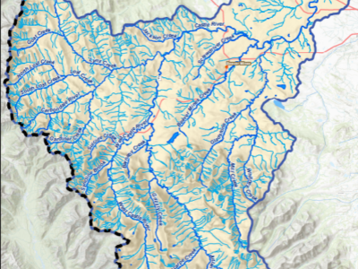
Under the land use framework (LUF) the province of Alberta intends to collect, update, and upgrade land-based information to support effective land use decisions. The provincial Base Hydrography is a core geospatial dataset that provides the underlying reference framework and context for land use decision making. To modernize these critical datasets, Alberta Environment and Protected Areas (AEPA) wanted to update polygon, line and point spatial and attribute data, and ensure these datasets conform to provincial specifications and formats. Updates to the Base Hydrography geospatial data used available digital orthophotography complemented by satellite imagery (SPOT-6/7) and other pertinent data sources, including Grassland Vegetation Inventory (GVI), Primary Land and Vegetation Inventory (PLVI), and Alberta Vegetation Inventory (AVI) where applicable.
Services Provided:
In four separate projects since 2020, Hatfield provided technical geomatics services to AEPA by updating the Base Hydrography datasets for 85,000 km2, using the provincial Base Hydrography Update Specification v2.5. Extensive QA/QC procedures were implemented including automated ArcPy scripts to validate topology, attribution, and network consistency. Other roles fulfilled by Hatfield included project management and coordination with AEPA to ensure timely delivery of products per contractual deadlines.