Scientific paper on mapping rice production intensity to support the transition to climate resilient agriculture in Vietnam published in the Canadian Journal of Remote Sensing
May 14, 2026
Hatfield is proud to announce a new scientific paper, “Mapping Rice Production Typology Using Sentinel-1 Time Series Similarity Analysis to Support Climate Resilient Agriculture in the Vietnamese Mekong Delta” is published in the Canadian Journal of Remote Sensing. The research was completed in collaboration with the International Union for Conservation of Nature (IUCN) Viet Nam and funded by the European Space Agency (ESA).
Vietnam’s Mekong Delta accounts for 50% of Vietnam’s rice production and 90% of its rice exports. To increase rice production, starting in the early 2000s, the government of Vietnam built high ring dikes (polders) to allow rice to mature during the peak flood season (September to mid-October). These polders enabled three annual rice crops (triple rice). While triple-rice cropping resulted in higher production, it damaged soils and ecosystems by preventing the delivery of nutrient-rich sediment, which required the use of large volumes of agricultural chemicals. It also fragmented the Mekong’s floodplain and increased flood risk downstream. In contrast, double-rice cropping allows for more natural flooding processes during the wet season. Recognizing the environmental and social benefits of lower intensity and more climate resilient agricultural systems, in 2017 the government of Vietnam introduced a policy to reduce the area under triple rice production.
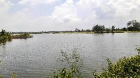
Image 1: Flooded rice field, typical for double rice (IUCN Vietnam (October 2023)).
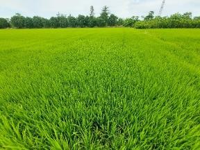
Image 2: Mature rice crop (IUCN Vietnam (October 2023)).
To evaluate the effectiveness of these policy initiatives, monitoring tools are needed to assess the progress of the transition from producing three rice crops to two rice crops per year. Our study, a collaboration between Hatfield and IUCN, achieved this by using Sentinel-1 synthetic aperture radar (SAR) satellite data, an effective approach for rice production monitoring that provides cloud-free observations of the Mekong Delta every 10 days. The novel analysis methodology included:
- Landscape segmentation to delineate homogeneous units for object-based analysis.
- Sentinel-1 backscatter time series generation for each unit to capture annual temporal dynamics.
- Identification of the predominant temporal backscatter patterns using t-distributed Stochastic Neighbor Embedding (t-SNE) and HDBSCAN clustering.
- Fieldwork to associate temporal backscatter patterns with double and triple Rice production typologies.
- Classification of rice typologies based on the most similar temporal profiles using Dynamic Time Warping (DTW).
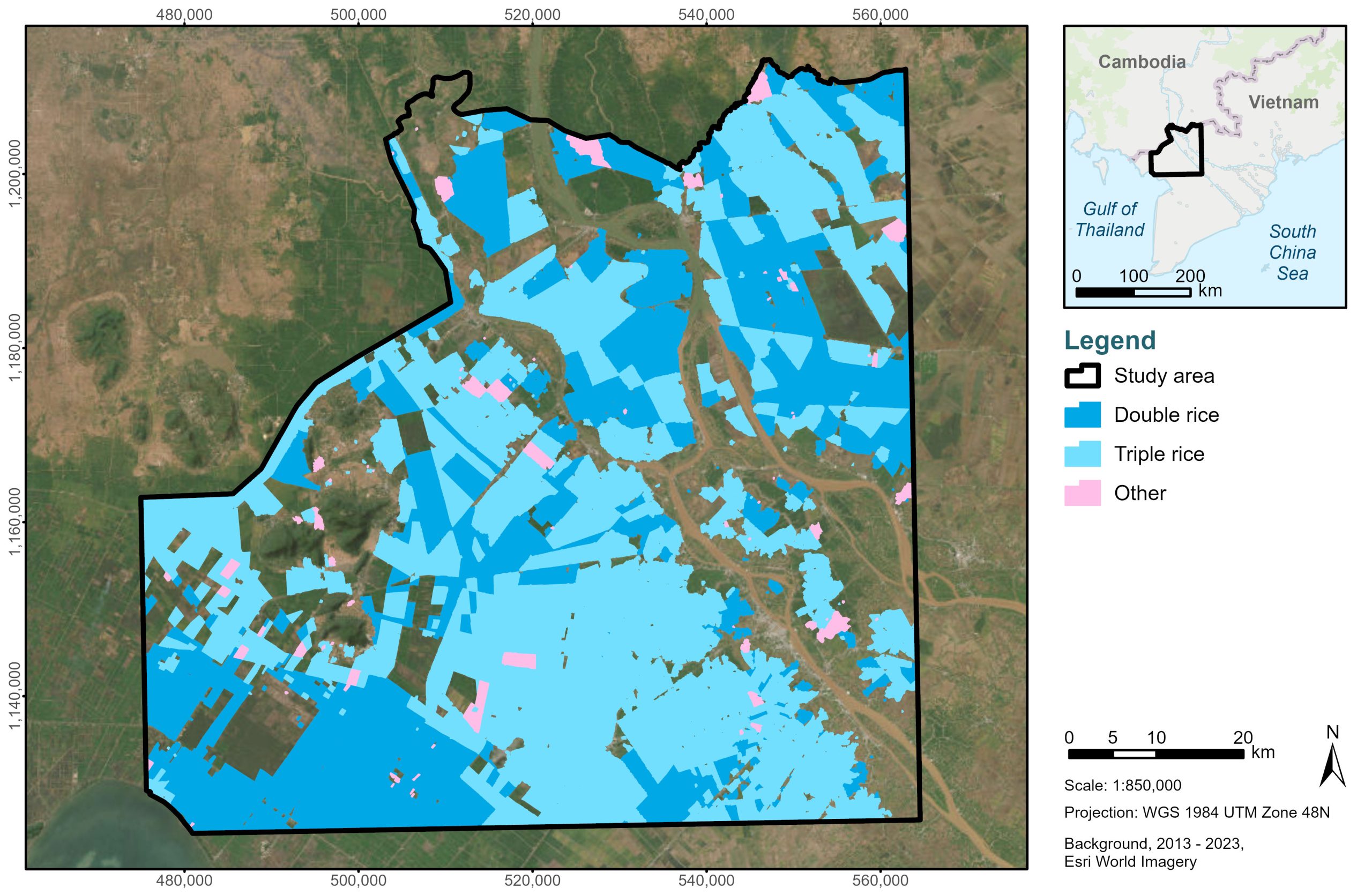
Figure 1: Study area showing double- and triple -rice cropping in 2019.
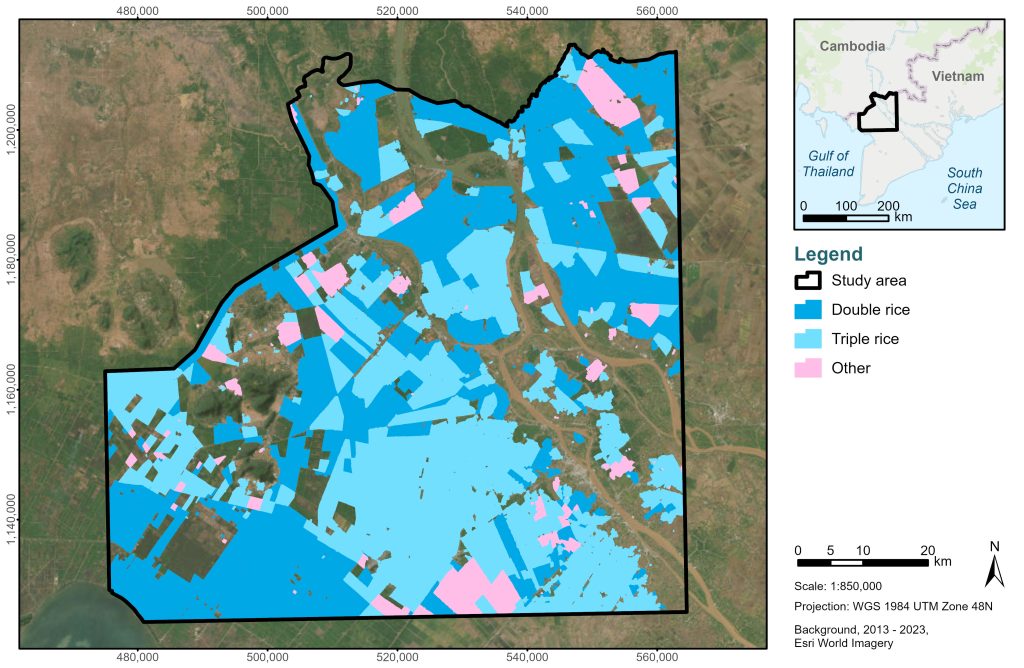
Figure 2: Study area showing double- and triple-rice cropping in 2022.
By analyzing seasonal growth cycles with time-series similarity methods, the team was able to distinguish between double- and triple-rice cropping systems across the region. The results show a decrease in triple-rice production between 2019 and 2022, alongside a shift towards less intensive double-cropping. With classification accuracy exceeding 83% in 2022, the findings provide strong evidence that national policies aimed at reducing intensive production and restoring natural floodplain functions are having a measurable impact in the Vietnamese Mekong Delta. This ecosystem restoration is critical to support climate change adaptation, food security, and disaster risk reduction in the Mekong Delta Region.
The research was made possible through the support of the ESA under the Pioneer Earth Observation aPplications for the Environment – Ecosystem Restoration (PEOPLE-ER) project. This scientific publication underscores the potential of satellite-based monitoring for reliable, large-scale insights to support ecosystem restoration monitoring and assessment.
View the full open-access publication, titled Mapping Rice Production Typology Using Sentinel-1 Time Series Similarity Analysis to Support Climate Resilient Agriculture in the Vietnamese Mekong Delta.
A GitHub repository containing a tutorial and test data to follow the steps carried out in this paper can be found here.
Learn more about Hatfield’s work using remote sensing applications for environmental monitoring and assessment here.
Research team comprised Andy Dean, Victor Tang, and Marcos Kavlin-Castaneda of Hatfield Consultants, Phong Nguyen Thanh and Jake Brunner of the International Union for Conservation of Nature, and Frank Martin Seifert from the European Space Agency.
