Hatfield Using RADARSAT-2 data to Support Cumulative Impact Monitoring in the Northwest Territories
Oct 30, 2013
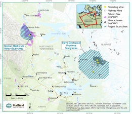
Hatfield is applying innovative satellite remote sensing (RS) and geographic information systems (GIS) methodologies to support collection of environmental baseline data and long-term monitoring of water resources in the Northwest Territories (NWT), Canada.
The “Using Earth Observation Data for Cumulative Impact Monitoring for Water Resources in the Northwest Territories” project is supported by the Canadian Space Agency’s Earth Observation Application Development Program. Territorial and Federal partners include the NWT Centre for Geomatics and Water Resources Division of Aboriginal Affairs and Northern Development Canada.
The overall goal of the project is to demonstrate and support the long-term application of satellite remote sensing a component of cumulative impact monitoring activities, particularly with respect to mapping the sensitivity of aquatic resources to ice formation and distribution. Project outputs will help address some information gaps in current monitoring and help characterize sensitive aquatic ecosystems.
The project will use data from RADARSAT-2 and RapidEye satellites to provide information and produce maps of lake ice conditions, surface water extents, wetland types and submerged aquatic vegetation. Seasonal, annual, and decadal trends will also be assessed using the extensive archive of RADARSAT data.
Cooperation with communities and local companies involved in transportation, drilling, mining, oil and gas, and companies involved in winter road development is a focus of the project. State-of-the-art regional environment monitoring programs are increasingly looking to apply remote sensing technologies to support field-based methods. Satellite remote sensing can be an important tool to monitor and collect environmental data for northern water bodies and for monitoring potential cumulative impacts of development activities.
Download the project brochure and learn how your company or organization can contribute and benefit from the project.

For more information, please contact us:
Dr. Andy Dean
Senior Geomatics Specialist and Partner
HATFIELD CONSULTANTS PARTNERSHIP
E-mail: hcp@hatfieldgroup.com
Tel.: +1-604–926-3261
Toll-Free: +1-866-926-3261
