Hatfield Presents Cumulative Effects Assessment GIS Analysis at ESRI Conference
Dec 02, 2013
Hatfield’s Geomatics Specialist, Mr. Agus Salim, presented Geodatabase Development for Cumulative Environmental Effects Assessment at ESRI Canada’s geographic information system (GIS) Users Conference in Vancouver, Canada.
Every environmental assessment in Canada must include consideration of the environmental effects of a project, including “any cumulative environmental effects that are likely to result from the project in combination with other projects or activities that have been or will be carried out.”
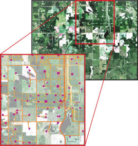
Hatfield’s environmental and GIS specialists have joined with Millennium Environmental Management Services (MEMS) for a number of proposed unconventional oil resources developments in Alberta, Canada. Mr. Salim presented Hatfield’s innovative use of satellite images, existing GIS datasets, and sophisticated GIS tools to support cumulative environmental effects assessment within a regional study area of 4,000 km2.
Area (polygon) and linear disturbance features such as, seismic lines, well pads, roads, and pipelines need to be captured to support a variety of assessments; such as, wildlife models. A geodatabase design and geo-processing method was established using: RapidEye images (5m pixel resolution); ABMI human footprint data; AltaLIS disposition data; well sites and pipeline data from Abacus Datagraphics. Following image processing and feature extraction, a geo-processing model in ArcGIS for Desktop was implemented. A key challenge in this endeavor was ensuring that topology issues in ABMI Human footprint data and other datasets were addressed.
Mr. Agus Salim is a Geomatics Specialist at Hatfield Consultants in North Vancouver, Canada. Mr. Salim has over 17 years of experience in the application of GIS and remote sensing for environmental management applications. He has managed large projects requiring spatial analysis to determine environmental sensitivity or conservation priorities. He possesses a Bachelor degree in Forestry.

Hatfield uses satellite remote sensing images to support environmental assessment of proposed resource development. In Alberta, Canada, Hatfield uses DigitalGlobe and RapidEye images for cumulative environmental effects for proposed oil and gas developments. Landscape disturbance features such as seismic lines, well pads, roads, and pipelines are captured within a geographic information system that can be used for a wide variety of applications.
Hatfield has extensive experience using ESRI ArcGIS for Desktop and ArcGIS for Server software, the world’s leading GIS software. We apply our understanding of environmental information requirements and use GIS and remote sensing technologies as a key part of our solutions to clients.
For more information, please contact us:
Dr. Andy Dean
Senior Geomatics Specialist and Partner
HATFIELD CONSULTANTS PARTNERSHIP
E-mail: hcp@hatfieldgroup.com
Tel.: +1-604–926-3261
Toll-Free: +1-866-926-3261
